|
search place name
|
||
Ismā‘īl Aghā ‘Abd Allāh (Arbīl, Iraq)Ismā‘īl Aghā ‘Abd Allāh is a town in the Arbīl region of Iraq. An overview map of the region around Ismā‘īl Aghā ‘Abd Allāh is displayed below.
regional and 3d topo map of Ismā‘īl Aghā ‘Abd Allāh, Iraq ::
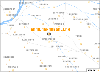
Nearby towns ::
Sayyid ‘Ubayd (2.1km south) //
Shōrah Zarkah (2.3km south) //
Ismā‘īl Āghā Aḩmad (3.1km east) //
Serdishān (4.3km north east) //
Mājidāwah (5.0km north west) //
Zamzamūk (5.4km north) //
Mullā Qarah (5.5km south east) //
Sijāla (6.2km west) //
Sayyid Amīr (8.0km north) //
Maklūbah (7.7km north west) //
Tall al Khaym (7.3km west) //
Kurranduru (8.3km south west) //
Nāmir (8.7km south west) //
Mājid Yūnus (8.2km south east) //
Bīrbirāzah (9.3km south) //
Ḩasan Bak (9.6km south east) //
[all distances 'as the bird flies' and approximate] 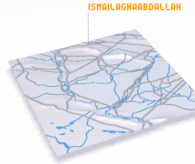 Places with similar names to Ismā‘īl Aghā ‘Abd Allāh, Iraq :: Disclaimer :: Information on this page comes without warranty of any kind |
||
|
Where is Ismā‘īl Aghā ‘Abd Allāh? Elevation and coordinates ::
Latitude (lat): 35°59'13"N Longitude (lon): 43°37'10"E
Elevation (approx.): 257m (map arrows pan, magnifying glasses zoom) |
||
|
Visiting Ismā‘īl Aghā ‘Abd Allāh? Hotel/Accommodation ::
Book a hotel in Ismā‘īl Aghā ‘Abd Allāh Travel Guide ::
Buy a travel guide for Iraq rental cars ::
car rental offers GPS waypoint ::
download a GPX waypoint (PoI) of Ismā‘īl Aghā ‘Abd Allāh for your GPS receiver
|
||