|
search place name
|
||
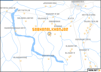
Sabhān al Khanjar (Al Qādisīyah, Iraq)Sabhān al Khanjar is a town in the Al Qādisīyah region of Iraq. An overview map of the region around Sabhān al Khanjar is displayed below.
regional and 3d topo map of Sabhān al Khanjar, Iraq ::
Nearby towns ::
Ḩamādī Āl ‘Abbās (0.3km north) //
Qaryat Jaḩab (1.5km north east) //
Kāmil Kāz̧im (3.1km east) //
Imām ‘Awn (3.6km north east) //
Nabī Ibrāhīm (4.5km north) //
Al Jawāsim (4.7km north) //
Nājī Khalīl (5.9km north) //
Ḩamd Allāh al ‘Uşfūr (6.0km north west) //
Ash Shāfi‘īyah (7.2km north) //
Sayyid Ḩāmid (7.3km north east) //
Qaryat Ja‘ib (8.6km south) //
Ghāzī Idrīs (8.4km south east) //
Ālbū Maţar (8.3km south east) //
Al ‘Aţāʼ (8.5km north east) //
Zabbālat Āl Maţrūd (9.8km south east) //
Āl Zuwayr (9.7km south east) //
Nabī Ways (9.7km south east) //
Āl Şabbāḩ (10.2km south east) //
[all distances 'as the bird flies' and approximate]  Places with similar names to Sabhān al Khanjar, Iraq :: Disclaimer :: Information on this page comes without warranty of any kind |
||
|
Where is Sabhān al Khanjar? Elevation and coordinates ::
Latitude (lat): 31°53'0"N Longitude (lon): 44°50'0"E
Elevation (approx.): 20m (map arrows pan, magnifying glasses zoom) |
||
|
Visiting Sabhān al Khanjar? Hotel/Accommodation ::
Book a hotel in Sabhān al Khanjar Travel Guide ::
Buy a travel guide for Iraq rental cars ::
car rental offers GPS waypoint ::
download a GPX waypoint (PoI) of Sabhān al Khanjar for your GPS receiver
|
||