|
search place name
|
||
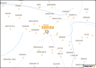
Sari Aw (Nīnawá, Iraq)Sari Aw is a town in the Nīnawá region of Iraq. An overview map of the region around Sari Aw is displayed below.
regional and 3d topo map of Sari Aw, Iraq ::
Sari Aw airports ::
The nearest airport is VAN - Van, located 198.2 km north of Sari Aw.
Nearby towns ::
Saryan (1.2km north west) //
Byok (1.3km west) //
Sarma (1.8km north west) //
‘Aqrah (2.2km north) //
Bashqāl (2.8km east) //
Jona (2.9km east) //
Kharba (4.2km north west) //
Samaqok (3.8km west) //
Hashtkah (5.8km north east) //
Mergin (5.2km south east) //
Sumel (6.3km south) //
Sarchawa (6.0km north west) //
Sharitan (6.9km north) //
Razōk (5.8km west) //
‘Amr Khūsh (6.9km south west) //
Darmila (7.4km south) //
Sitka (7.8km south east) //
Kharjawa (8.4km south) //
Musawa (7.2km west) //
Dzoki (7.4km south east) //
Nahāwa (8.0km south east) //
Halin (9.7km south east) //
Mazringan (9.3km north east) //
Girbish (9.6km north east) //
Barawa (11.0km south east) //
[all distances 'as the bird flies' and approximate] 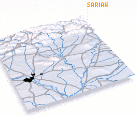 Places with similar names to Sari Aw, Iraq ::
Disclaimer :: Information on this page comes without warranty of any kind |
||
|
Where is Sari Aw? Elevation and coordinates ::
Latitude (lat): 36°44'24"N Longitude (lon): 43°53'58"E
Elevation (approx.): 615m (map arrows pan, magnifying glasses zoom) |
||
|
Visiting Sari Aw? Hotel/Accommodation ::
Book a hotel in Sari Aw Travel Guide ::
Buy a travel guide for Iraq rental cars ::
car rental offers GPS waypoint ::
download a GPX waypoint (PoI) of Sari Aw for your GPS receiver
|
||