|
search place name
|
||
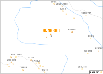
Ālmarān (Ostān-e Āz̄arbāyjān-e Gharbī, Iran)Ālmarān is a town in the Ostān-e Āz̄arbāyjān-e Gharbī region of Iran. An overview map of the region around Ālmarān is displayed below.
regional and 3d topo map of Ālmarān, Iran ::
Ālmarān airports ::
The nearest airport is TBZ - Tabriz Intl, located 207.6 km north east of Ālmarān.
Other airports nearby include SDG - Sanandaj (209.9 km south east), Nearby towns ::
Badrābād (1.5km west) //
Ghāzān (6.2km east) //
Tarkesh-e Soflá (9.3km north east) //
Qobād Beygīān (9.4km north east) //
Razga (10.3km south west) //
[all distances 'as the bird flies' and approximate] 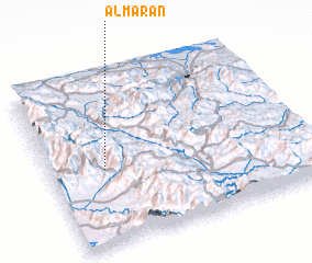 Places with similar names to Ālmarān, Iran ::
// Alì Marina (IT)
// Al Amrīnī (IQ)
// Al Marān (SY)
// Al Marrānah (SY)
// Al Marrānah (SY)
// Al ‘Amārinah (EG)
// Al ‘Umrān (TN)
// Al ‘Amārīn (SD)
// Al ‘Umrān (SA)
// Almeriana (BR)
Disclaimer :: Information on this page comes without warranty of any kind |
||
|
Where is Ālmarān? Elevation and coordinates ::
Latitude (lat): 36°27'0"N Longitude (lon): 45°13'0"E
Elevation (approx.): 2153m (map arrows pan, magnifying glasses zoom) |
||
|
Visiting Ālmarān? Hotel/Accommodation ::
Book a hotel in Ālmarān Travel Guide ::
Buy a travel guide for Iran rental cars ::
car rental offers GPS waypoint ::
download a GPX waypoint (PoI) of Ālmarān for your GPS receiver
|
||