|
search place name
|
||
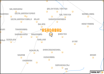
Asadābād (Iran)Asadābād is a town in Iran. An overview map of the region around Asadābād is displayed below.
regional and 3d topo map of Asadābād, Iran ::
Asadābād airports ::
The nearest airport is RAS - Rasht, located 130.1 km north east of Asadābād.
Other airports nearby include RZR - Ramsar (181.4 km east), SDG - Sanandaj (201.7 km south west), Nearby towns ::
Kabūd Gonbad (2.4km north west) //
Qīāsīyeh (3.0km east) //
Shalvār (3.5km south west) //
Owlang (4.8km north west) //
Emāmzādeh Esmā‘īl (5.6km south) //
Nāderābād (4.5km west) //
Shahr-e Kharābeh (5.8km north) //
Torkān Deh (6.3km south east) //
Emāmzādeh Qāsem (7.4km north) //
Emāmzādeh Ebrāhīm (7.4km north) //
Chap Darreh (6.0km west) //
Arjīn (7.1km north west) //
Kūshkābād (8.2km south) //
Vīyar (7.1km east) //
Solţānīyeh (8.1km north east) //
Deh Jalāl (7.7km south west) //
[all distances 'as the bird flies' and approximate] 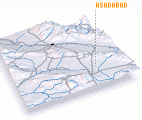 Places with similar names to Asadābād, Iran ::
Disclaimer :: Information on this page comes without warranty of any kind |
||
|
Where is Asadābād? Elevation and coordinates ::
Latitude (lat): 36°22'0"N Longitude (lon): 48°46'0"E
Elevation (approx.): 1930m (map arrows pan, magnifying glasses zoom) |
||
|
Visiting Asadābād? Hotel/Accommodation ::
Book a hotel in Asadābād Travel Guide ::
Buy a travel guide for Iran rental cars ::
car rental offers GPS waypoint ::
download a GPX waypoint (PoI) of Asadābād for your GPS receiver
|
||