|
search place name
|
||
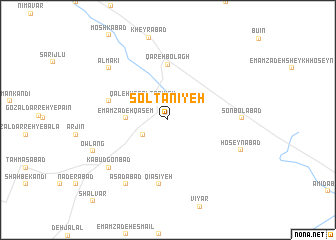
Solţānīyeh (Iran)Solţānīyeh is a town in Iran. An overview map of the region around Solţānīyeh is displayed below.
regional and 3d topo map of Solţānīyeh, Iran ::
Solţānīyeh airports ::
The nearest airport is RAS - Rasht, located 122.0 km north east of Solţānīyeh.
Other airports nearby include RZR - Ramsar (175.5 km east), SDG - Sanandaj (209.1 km south west), Nearby towns ::
Shahr-e Kharābeh (2.8km south west) //
Nīmeh Īstgāh-e Sonbolābād (3.0km north east) //
Qal‘eh-ye Solţānīyeh (3.1km north west) //
Emāmzādeh Qāsem (3.8km west) //
Emāmzādeh Ebrāhīm (3.8km west) //
Qareh Bolāgh (6.2km north) //
‘Abbāsābād (5.7km west) //
Qīāsīyeh (7.2km south) //
Sonbolābād (6.7km east) //
Kabūd Gonbad (7.5km south west) //
Asadābād (8.1km south west) //
Almakī (7.8km north west) //
Ḩoseynābād (7.4km south east) //
Owlang (7.6km south west) //
[all distances 'as the bird flies' and approximate]  Places with similar names to Solţānīyeh, Iran ::
// Zaleden'ye (RU)
// Zaledin'ye (RU)
// Zlatynya (RU)
// Sultaniye (TR)
// Sultaniye (TR)
// Sultaniye (TR)
// Sultaniye (TR)
// Sultaniye (TR)
// Sultaniye (TR)
// Sultaniye (TR)
Disclaimer :: Information on this page comes without warranty of any kind |
||
|
Where is Solţānīyeh? Elevation and coordinates ::
Latitude (lat): 36°25'53"N Longitude (lon): 48°48'32"E
Elevation (approx.): 1786m (map arrows pan, magnifying glasses zoom) |
||
|
Visiting Solţānīyeh? Hotel/Accommodation ::
Book a hotel in Solţānīyeh Travel Guide ::
Buy a travel guide for Iran rental cars ::
car rental offers GPS waypoint ::
download a GPX waypoint (PoI) of Solţānīyeh for your GPS receiver
|
||