|
search place name
|
||
Baldīyeh (Khūzestān, Iran)Baldīyeh is a town in the Khūzestān region of Iran. An overview map of the region around Baldīyeh is displayed below.
regional and 3d topo map of Baldīyeh, Iran ::

Baldīyeh airports ::
The nearest airport is AWZ - Ahwaz, located 25.5 km north of Baldīyeh.
Other airports nearby include MRX - Bandar Mahshahr Mahshahr (71.1 km south east), ABD - Abadan (96.9 km south west), QMJ - Masjed Soleiman Shahid Asyaee (109.9 km north east), BSR - Basrah Intl (123.0 km south west), Nearby towns ::
Z̄owq (1.0km south west) //
Malīch-e Kūchek (2.3km north west) //
Malīch-e Bozorg (4.9km north) //
A‘ẕab (4.8km west) //
Qadar (6.7km north west) //
Khosravīyeh (6.9km south east) //
Īstgāh-e Khosravī (6.7km south east) //
Manīzh (6.4km north east) //
Jarbāh (7.3km north) //
Khenẕīrī (6.7km south west) //
Ḩanaţīyeh (8.1km south) //
Tambūdorūsheyd (7.3km north east) //
Man Sar (7.7km north east) //
Ţovayel (9.4km south west) //
Al ‘Aqdā (10.4km north west) //
[all distances 'as the bird flies' and approximate] 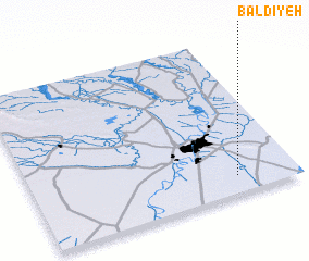 Places with similar names to Baldīyeh, Iran ::
// Belādīyeh (IR)
// Blédaya (TD)
// Biltiya (IN)
// Bala Diaye (SN)
// Ballūţīyah (SY)
// Bolduye (LR)
// Bolo Doyo (ET)
Disclaimer :: Information on this page comes without warranty of any kind |
||
|
Where is Baldīyeh? Elevation and coordinates ::
Latitude (lat): 31°6'28"N Longitude (lon): 48°46'22"E
Elevation (approx.): 10m (map arrows pan, magnifying glasses zoom) |
||
|
Visiting Baldīyeh? Hotel/Accommodation ::
Book a hotel in Baldīyeh Travel Guide ::
Buy a travel guide for Iran rental cars ::
car rental offers GPS waypoint ::
download a GPX waypoint (PoI) of Baldīyeh for your GPS receiver
|
||