|
search place name
|
||
Khenẕīrī (Khūzestān, Iran)Khenẕīrī is a town in the Khūzestān region of Iran. An overview map of the region around Khenẕīrī is displayed below.
regional and 3d topo map of Khenẕīrī, Iran ::

Khenẕīrī airports ::
The nearest airport is AWZ - Ahwaz, located 28.6 km north of Khenẕīrī.
Other airports nearby include MRX - Bandar Mahshahr Mahshahr (72.3 km south east), ABD - Abadan (91.4 km south west), QMJ - Masjed Soleiman Shahid Asyaee (115.0 km north east), BSR - Basrah Intl (116.3 km south west), Nearby towns ::
A‘ẕab (3.7km north east) //
Ţovayel (5.7km south) //
Mūnes (5.8km west) //
Z̄owq (5.9km east) //
Malīch-e Kūchek (6.6km north east) //
Baldīyeh (6.7km north east) //
Mokhannas̄ (7.3km west) //
Moʼnes (7.3km west) //
Qadar (8.8km north) //
Ḩamdānīyeh-ye Kūchek (9.3km south west) //
Malīch-e Bozorg (10.5km north east) //
[all distances 'as the bird flies' and approximate] 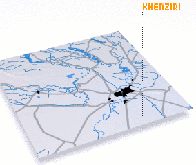 Places with similar names to Khenẕīrī, Iran ::
// Khān as Sūr (IQ)
// Khān Zūr (IQ)
// Khiunsar (IN)
// Khan-Nazar (UZ)
// Khāneh Sar (IR)
// Khāneh Sar (IR)
// Khūnī Sar (IR)
// Khānsar (PK)
// Khīnsar (PK)
// Khinsar (PK)
Disclaimer :: Information on this page comes without warranty of any kind |
||
|
Where is Khenẕīrī? Elevation and coordinates ::
Latitude (lat): 31°5'3"N Longitude (lon): 48°42'27"E
Elevation (approx.): 11m (map arrows pan, magnifying glasses zoom) |
||
|
Visiting Khenẕīrī? Hotel/Accommodation ::
Book a hotel in Khenẕīrī Travel Guide ::
Buy a travel guide for Iran rental cars ::
car rental offers GPS waypoint ::
download a GPX waypoint (PoI) of Khenẕīrī for your GPS receiver
|
||