|
search place name
|
||
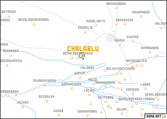
Chalablū (Iran)Chalablū is a town in Iran. An overview map of the region around Chalablū is displayed below.
regional and 3d topo map of Chalablū, Iran ::
Chalablū airports ::
The nearest airport is THR - Teheran Mehrabad Intl, located 121.2 km north east of Chalablū.
Other airports nearby include RZR - Ramsar (217.0 km north), Nearby towns ::
Qeshlāq-e Mazre‘eh (1.1km west) //
Mazra‘eh-ye Sharaflū (2.2km west) //
Yalābād (2.9km south) //
Qardīn (4.1km south) //
Olūsjerd (4.6km south east) //
Holūl (5.7km south) //
Seqānlīq (6.2km north) //
Sorkheh Deh (6.8km south) //
Maḩmūdābād (7.3km south east) //
Lālā'īn (8.0km south) //
Olūsjerd (6.8km south east) //
Nūr ‘Alī Beyg (8.1km north) //
Sāveh (7.4km north east) //
Qal‘eh-ye ‘Azīzkhān (7.4km south east) //
Palas Khān (8.2km south east) //
Āsīābak-e Band (9.1km south west) //
Dālestān (9.6km south east) //
‘Abdollāhābād (9.9km north east) //
[all distances 'as the bird flies' and approximate]  Places with similar names to Chalablū, Iran ::
// Tialbol (SN)
// Chilubula (ZM)
// Shalubala (ZM)
// Shilibelo (ZM)
// Sialubilo (ZM)
// Choli Bāla (PK)
// Ch'ilbul-li (KP)
Disclaimer :: Information on this page comes without warranty of any kind |
||
|
Where is Chalablū? Elevation and coordinates ::
Latitude (lat): 34°58'43"N Longitude (lon): 50°18'3"E
Elevation (approx.): 1039m (map arrows pan, magnifying glasses zoom) |
||
|
Visiting Chalablū? Hotel/Accommodation ::
Book a hotel in Chalablū Travel Guide ::
Buy a travel guide for Iran rental cars ::
car rental offers GPS waypoint ::
download a GPX waypoint (PoI) of Chalablū for your GPS receiver
|
||