|
search place name
|
||
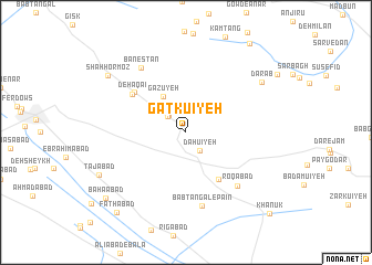
Gatkū'īyeh (Kermān, Iran)Gatkū'īyeh is a town in the Kermān region of Iran. An overview map of the region around Gatkū'īyeh is displayed below.
regional and 3d topo map of Gatkū'īyeh, Iran ::
Gatkū'īyeh airports ::
The nearest airport is KER - Kerman, located 62.8 km south of Gatkū'īyeh.
Nearby towns ::
Dāhū'īyeh (2.2km south east) //
Akbarābād (2.3km north west) //
Gezū'īyeh (2.3km north west) //
Deh Aḩmad (3.1km north west) //
Gazūyeh (4.2km north west) //
Deh Aşghar (5.6km south east) //
Ābpangū'īyeh (6.0km north west) //
Deh Aqā'ī (6.0km north west) //
Roqābād (7.0km south east) //
Bab Tangal-e Pā'īn (7.5km south) //
Banestān (7.6km north west) //
Darāb (8.3km north east) //
Shāh Hormoz (8.9km north west) //
Tājābād (8.7km south west) //
Bahā'ābād (9.6km south west) //
Fatḩābād (10.1km south west) //
Khānūk (10.9km south east) //
[all distances 'as the bird flies' and approximate]  Places with similar names to Gatkū'īyeh, Iran ::
Disclaimer :: Information on this page comes without warranty of any kind |
||
|
Where is Gatkū'īyeh? Elevation and coordinates ::
Latitude (lat): 30°47'56"N Longitude (lon): 56°42'12"E
Elevation (approx.): 2064m (map arrows pan, magnifying glasses zoom) |
||
|
Visiting Gatkū'īyeh? Hotel/Accommodation ::
Book a hotel in Gatkū'īyeh Travel Guide ::
Buy a travel guide for Iran rental cars ::
car rental offers GPS waypoint ::
download a GPX waypoint (PoI) of Gatkū'īyeh for your GPS receiver
|
||