|
search place name
|
||
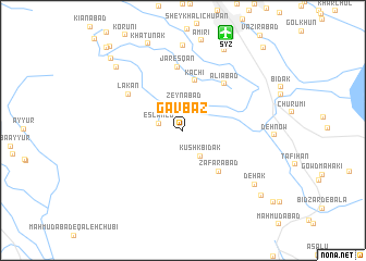
Gāv Bāz (Fārs, Iran)Gāv Bāz is a town in the Fārs region of Iran. An overview map of the region around Gāv Bāz is displayed below.
regional and 3d topo map of Gāv Bāz, Iran ::
Gāv Bāz airports ::
The nearest airport is SYZ - Shiraz Shahid Dastghaib Intl, located 10.6 km north of Gāv Bāz.
Other airports nearby include BUZ - Bushehr (176.0 km west), Nearby towns ::
Sanjānak (2.0km north) //
Eslāmlū (2.3km west) //
Zeynābād (2.7km north) //
Kūshk Bīdak (3.0km south east) //
Kachī (5.2km north) //
Z̧afarābād (5.3km south east) //
‘Alīābād (6.0km north east) //
Jaresqān (6.5km north) //
Lakān (6.1km north west) //
Solţānābād (8.7km north) //
Dehak (8.5km south east) //
Dūdmān (9.0km north east) //
Kafrī (8.7km north west) //
Khātūnak (9.4km north) //
Ja‘farābād (9.5km north east) //
Dowlatābād (9.7km south east) //
Maḩmūdābād (9.8km north west) //
Jamālābād (10.8km north west) //
Pīr Yenū (10.9km north west) //
Rovānī (11.1km north east) //
[all distances 'as the bird flies' and approximate] 
Disclaimer :: Information on this page comes without warranty of any kind |
||
|
Where is Gāv Bāz? Elevation and coordinates ::
Latitude (lat): 29°27'0"N Longitude (lon): 52°33'0"E
Elevation (approx.): 1477m (map arrows pan, magnifying glasses zoom) |
||
|
Visiting Gāv Bāz? Hotel/Accommodation ::
Book a hotel in Gāv Bāz Travel Guide ::
Buy a travel guide for Iran rental cars ::
car rental offers GPS waypoint ::
download a GPX waypoint (PoI) of Gāv Bāz for your GPS receiver
|
||