|
search place name
|
||
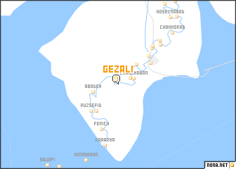
Gezālī (Khūzestān, Iran)Gezālī is a town in the Khūzestān region of Iran. An overview map of the region around Gezālī is displayed below.
regional and 3d topo map of Gezālī, Iran ::
Gezālī airports ::
The nearest airport is MRX - Bandar Mahshahr Mahshahr, located 63.5 km north west of Gezālī.
Other airports nearby include ABD - Abadan (139.8 km west), AWZ - Ahwaz (153.2 km north west), BUZ - Bushehr (179.1 km south east), KWI - Kuwait Intl (196.5 km south west), Nearby towns ::
Gharābī-ye Bozorg (0.8km north) //
Gharābī-ye Kūchek (1.9km north east) //
Cham Sha‘bān (2.3km north east) //
Ābādeh (3.6km west) //
Cham Qāẕī (4.1km north east) //
Badrānī (5.2km south west) //
Pūz Sefīd (5.5km south west) //
Kūchek (5.6km north east) //
Hendījān (6.2km north east) //
Ferīch (7.4km south) //
Emāmzādeh Raḩmān (7.4km north east) //
Hendījār (7.8km north east) //
Cham Raḩmān (8.6km north east) //
Z̧olmābād (9.0km north east) //
Cham Morād (11.0km north east) //
[all distances 'as the bird flies' and approximate]  Places with similar names to Gezālī, Iran ::
Disclaimer :: Information on this page comes without warranty of any kind |
||
|
Where is Gezālī? Elevation and coordinates ::
Latitude (lat): 30°11'54"N Longitude (lon): 49°40'4"E
Elevation (approx.): 5m (map arrows pan, magnifying glasses zoom) |
||
|
Visiting Gezālī? Hotel/Accommodation ::
Book a hotel in Gezālī Travel Guide ::
Buy a travel guide for Iran rental cars ::
car rental offers GPS waypoint ::
download a GPX waypoint (PoI) of Gezālī for your GPS receiver
|
||