|
search place name
|
||
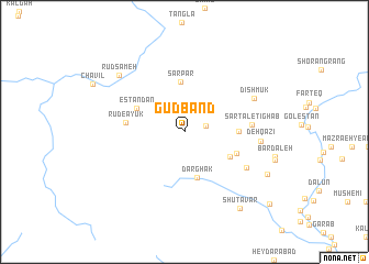
Gūdband (Ostān-e Kohgīlūyeh va Būyer Aḩmad, Iran)Gūdband is a town in the Ostān-e Kohgīlūyeh va Būyer Aḩmad region of Iran. An overview map of the region around Gūdband is displayed below.
regional and 3d topo map of Gūdband, Iran ::
Gūdband airports ::
The nearest airport is QMJ - Masjed Soleiman Shahid Asyaee, located 130.1 km north west of Gūdband.
Other airports nearby include MRX - Bandar Mahshahr Mahshahr (137.3 km south west), AWZ - Ahwaz (149.8 km west), Nearby towns ::
Sar Rūd-e Ayvak (1.9km east) //
Delī (2.5km north) //
Darghak (4.8km south) //
Sar Par (5.1km north) //
Darreh Gerūh Pā'īn (4.7km south east) //
Estandān (4.8km north west) //
Sartal (4.8km east) //
Darreh Gerūh Bālā (5.0km south east) //
Rūd-e Ayūk (5.2km west) //
Sartal-e Tīghāb (5.9km east) //
Sar Ghol (6.5km south east) //
Deh Qāẕī (6.7km east) //
Dīshmūk (6.9km north east) //
Rūdsameh (8.1km north west) //
Bar Āftāb-e Emām Reẕā (8.4km south east) //
Shūtāvar (9.2km south east) //
Chahār Rāh (10.4km south east) //
[all distances 'as the bird flies' and approximate] 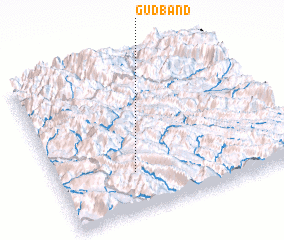 Places with similar names to Gūdband, Iran ::
// Gudibanda (IN)
// Godobuneto (GH)
// Katabanda (UG)
// Katabanda (UG)
// Kotibanta (NE)
// Gowd-e Band (IR)
// Gudi Bānda (PK)
// Gudu Bānda (PK)
// Kōt Banda (PK)
// Kot Banda (PK)
Disclaimer :: Information on this page comes without warranty of any kind |
||
|
Where is Gūdband? Elevation and coordinates ::
Latitude (lat): 31°15'39"N Longitude (lon): 50°19'58"E
Elevation (approx.): 1606m (map arrows pan, magnifying glasses zoom) |
||
|
Visiting Gūdband? Hotel/Accommodation ::
Book a hotel in Gūdband Travel Guide ::
Buy a travel guide for Iran rental cars ::
car rental offers GPS waypoint ::
download a GPX waypoint (PoI) of Gūdband for your GPS receiver
|
||