|
search place name
|
||
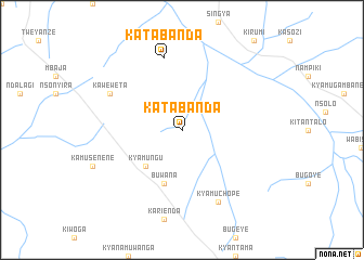
Katabanda (Busoga, Uganda)Katabanda is a town in the Busoga region of Uganda. An overview map of the region around Katabanda is displayed below.
regional and 3d topo map of Katabanda, Uganda ::
Katabanda airports ::
The nearest airport is EBB - Entebbe Intl, located 132.3 km south of Katabanda.
Other airports nearby include SRT - Soroti (166.4 km east), BUX - Bunia (225.4 km west), Nearby towns ::
Kyamungu (5.2km south west) //
Buwana (5.9km south) //
Katabanda (7.6km north) //
Kaweweta (8.3km north west) //
Kyamuchope (8.3km south east) //
[all distances 'as the bird flies' and approximate]  Places with similar names to Katabanda, Uganda ::
// Gudibanda (IN)
// Godobuneto (GH)
// Katabanda (UG)
// Kotibanta (NE)
// Gowd-e Band (IR)
// Gūdband (IR)
// Gudi Bānda (PK)
// Gudu Bānda (PK)
// Kōt Banda (PK)
// Kot Banda (PK)
Disclaimer :: Information on this page comes without warranty of any kind |
||
|
Where is Katabanda? Elevation and coordinates ::
Latitude (lat): 1°13'0"N Longitude (lon): 32°13'0"E
Elevation (approx.): 1073m (map arrows pan, magnifying glasses zoom) |
||
|
Visiting Katabanda? Hotel/Accommodation ::
Book a hotel in Katabanda Travel Guide ::
Buy a travel guide for Uganda rental cars ::
car rental offers GPS waypoint ::
download a GPX waypoint (PoI) of Katabanda for your GPS receiver
|
||