|
search place name
|
||
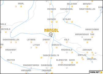
Mangol (Iran)Mangol is a town in Iran. An overview map of the region around Mangol is displayed below.
regional and 3d topo map of Mangol, Iran ::
Mangol airports ::
The nearest airport is THR - Teheran Mehrabad Intl, located 113.6 km south west of Mangol.
Other airports nearby include RZR - Ramsar (167.8 km north west), Nearby towns ::
‘Emārat (2.4km south west) //
Paran (2.4km south west) //
Balākūn (4.0km south) //
Shāhzeyd (4.0km south) //
Karsank (5.6km north) //
Īstgāh-e Jangalbānī (5.6km north) //
Āzād Kotī (5.8km north) //
Koln (4.9km east) //
Līt Kūh (5.8km south west) //
Shāh Zeyd-e ‘Olyā (7.5km south) //
Latband (6.3km west) //
Pāshā Kolā (7.1km south east) //
Pārīmeh (7.1km south east) //
Kītājān (7.1km north east) //
Kamarbon (7.0km south west) //
Alrap (8.0km south) //
Najjār Kolā (8.2km south east) //
Khalārd (8.2km north east) //
[all distances 'as the bird flies' and approximate]  Places with similar names to Mangol, Iran ::
// Managale (MM)
// Mangla (MM)
// Mān Ka-lao (MM)
// Mān Kalu (MM)
// Mān Nawkla (MM)
// Maungla (MM)
// Maunglaw (MM)
// Mingala (MM)
// Mingala (MM)
// Möng La (MM)
Disclaimer :: Information on this page comes without warranty of any kind |
||
|
Where is Mangol? Elevation and coordinates ::
Latitude (lat): 36°15'0"N Longitude (lon): 52°22'0"E
Elevation (approx.): 477m (map arrows pan, magnifying glasses zoom) |
||
|
Visiting Mangol? Hotel/Accommodation ::
Book a hotel in Mangol Travel Guide ::
Buy a travel guide for Iran rental cars ::
car rental offers GPS waypoint ::
download a GPX waypoint (PoI) of Mangol for your GPS receiver
|
||