|
search place name
|
||
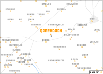
Qareh Dāgh (Iran)Qareh Dāgh is a town in Iran. An overview map of the region around Qareh Dāgh is displayed below.
regional and 3d topo map of Qareh Dāgh, Iran ::
Qareh Dāgh airports ::
The nearest airport is THR - Teheran Mehrabad Intl, located 244.4 km north east of Qareh Dāgh.
Nearby towns ::
Qānyārūq-e Soflá (1.9km north) //
Bābā ‘Alī (2.4km south west) //
Robāţ Mīl (2.4km south west) //
Qānyārūq-e ‘Olyā (4.0km north) //
Khānehmīrān (5.0km south east) //
Fījān (4.9km north east) //
Namak Kūr (5.2km north west) //
Namak Kūr (5.9km north west) //
Ẕāmenjān (5.8km east) //
Qal‘eh -ye Karān (6.1km east) //
Jamunjān (6.1km east) //
Senjān (6.4km east) //
Ţarlān (8.0km north) //
Sāqī (8.5km north) //
Qal‘eh (8.3km north west) //
Now Deh (9.6km north west) //
Kaleh-ye Namak Kūr (9.6km north west) //
Gūsheh (11.3km south east) //
[all distances 'as the bird flies' and approximate] 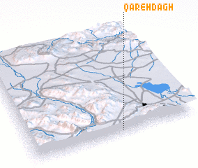 Places with similar names to Qareh Dāgh, Iran ::
Disclaimer :: Information on this page comes without warranty of any kind |
||
|
Where is Qareh Dāgh? Elevation and coordinates ::
Latitude (lat): 34°2'0"N Longitude (lon): 49°33'0"E
Elevation (approx.): 2003m (map arrows pan, magnifying glasses zoom) |
||
|
Visiting Qareh Dāgh? Hotel/Accommodation ::
Book a hotel in Qareh Dāgh Travel Guide ::
Buy a travel guide for Iran rental cars ::
car rental offers GPS waypoint ::
download a GPX waypoint (PoI) of Qareh Dāgh for your GPS receiver
|
||