|
search place name
|
||
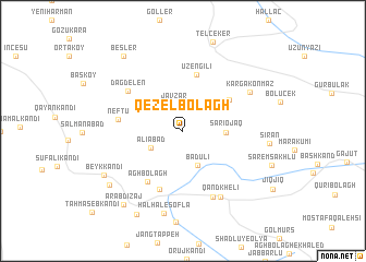
Qezel Bolāgh (Ostān-e Āz̄arbāyjān-e Gharbī, Iran)Qezel Bolāgh is a town in the Ostān-e Āz̄arbāyjān-e Gharbī region of Iran. An overview map of the region around Qezel Bolāgh is displayed below.
regional and 3d topo map of Qezel Bolāgh, Iran ::
Qezel Bolāgh airports ::
The nearest airport is VAN - Van, located 127.3 km south west of Qezel Bolāgh.
Nearby towns ::
Javzar (2.9km north) //
‘Alīābād (3.0km south west) //
Badūlī (3.7km south) //
Sārī Ojāq (3.4km east) //
Yiğityatağı (4.9km north east) //
Üzengili (5.9km north) //
Āghbolāgh (5.9km south west) //
‘Alūjīnī (6.2km south) //
Nefţū (5.3km west) //
Dağdelen (6.0km north west) //
Keshtāz (7.2km south) //
Qand Khelī (7.3km south east) //
Kargakonmaz (6.6km north east) //
Ḩālḩāl-e Soflá (8.5km south) //
Beyk Kandī (7.7km south west) //
Kelīsā Kandī (8.0km south west) //
‘Arab Dīzaj (8.9km south west) //
Besler (8.9km north west) //
Qolīdīzaj (9.3km south west) //
[all distances 'as the bird flies' and approximate]  Places with similar names to Qezel Bolāgh, Iran ::
// Gozalbolāghī (IR)
// Gūzal Bolāgh (IR)
// Qezel Bolāgh (IR)
// Qezel Bolāgh (IR)
// Qezel Bolāgh (IR)
// Qezel Bolāgh (IR)
// Qezel Bolāgh (IR)
// Qezel Bolāgh (IR)
Disclaimer :: Information on this page comes without warranty of any kind |
||
|
Where is Qezel Bolāgh? Elevation and coordinates ::
Latitude (lat): 39°22'53"N Longitude (lon): 44°13'16"E
Elevation (approx.): 2100m (map arrows pan, magnifying glasses zoom) |
||
|
Visiting Qezel Bolāgh? Hotel/Accommodation ::
Book a hotel in Qezel Bolāgh Travel Guide ::
Buy a travel guide for Iran rental cars ::
car rental offers GPS waypoint ::
download a GPX waypoint (PoI) of Qezel Bolāgh for your GPS receiver
|
||