|
search place name
|
||
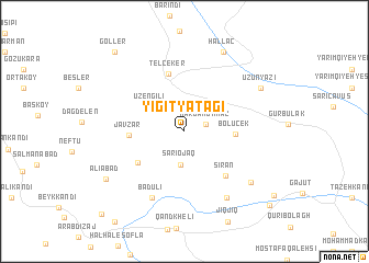
Yiğityatağı (Ağrı, Turkey)Yiğityatağı is a town in the Ağrı region of Turkey. An overview map of the region around Yiğityatağı is displayed below.
regional and 3d topo map of Yiğityatağı, Turkey ::
Yiğityatağı airports ::
The nearest airport is VAN - Van, located 132.1 km south west of Yiğityatağı.
Other airports nearby include TBZ - Tabriz Intl (222.3 km south east), Nearby towns ::
Kargakonmaz (1.8km north east) //
Sārī Ojāq (3.4km south) //
Üzengili (3.7km north west) //
Bölücek (4.0km east) //
Javzar (4.4km west) //
Qezel Bolāgh (4.9km south west) //
Telçeker (6.0km north) //
Sīrān (5.5km south east) //
Badūlī (7.2km south) //
Sārem Sākhlū (7.5km south east) //
Mārākūmī (7.3km south east) //
Uzunyazı (7.4km north east) //
Hallaç (8.7km north) //
‘Alīābād (7.9km south west) //
Göller (9.8km north west) //
Mehdī Bolāghī (10.1km south east) //
Āghbolāgh (10.6km south west) //
[all distances 'as the bird flies' and approximate]  Places with similar names to Yiğityatağı, Turkey :: Disclaimer :: Information on this page comes without warranty of any kind |
||
|
Where is Yiğityatağı? Elevation and coordinates ::
Latitude (lat): 39°24'37"N Longitude (lon): 44°15'50"E
Elevation (approx.): 1990m (map arrows pan, magnifying glasses zoom) |
||
|
Visiting Yiğityatağı? Hotel/Accommodation ::
Book a hotel in Yiğityatağı Travel Guide ::
Buy a travel guide for Turkey rental cars ::
car rental offers GPS waypoint ::
download a GPX waypoint (PoI) of Yiğityatağı for your GPS receiver
|
||