|
search place name
|
||
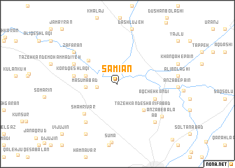
Sāmīān (Ostān-e Āz̄arbāyjān-e Gharbī, Iran)Sāmīān is a town in the Ostān-e Āz̄arbāyjān-e Gharbī region of Iran. An overview map of the region around Sāmīān is displayed below.
regional and 3d topo map of Sāmīān, Iran ::
Sāmīān airports ::
The nearest airport is RAS - Rasht, located 166.7 km south east of Sāmīān.
Nearby towns ::
Jabahdār (2.6km west) //
Ma‘şūmābād (4.1km west) //
Ḩayehdār (4.2km west) //
Tāzeh Kand-e Sharīfābād (5.3km south east) //
Ţāleb Qeshlāqī (5.2km north west) //
Āqcheh Kandī (5.3km south east) //
Kord Qeshlāqī (5.6km west) //
Shahrīvar (6.3km south west) //
Naqdī Kandī (6.3km north west) //
Garjān (7.3km south west) //
Mārānī (7.3km south west) //
Āb (7.7km south east) //
Za‘farān (7.4km north west) //
Anzāb-e Bālā (7.6km south east) //
Dāshlūjeh (8.9km north) //
Āqājān Khān (8.9km south west) //
Vījūjīn (10.5km south west) //
Bārūq (10.5km south west) //
Kalkhowrān Sheykh (11.2km south east) //
Jamāyrān (11.2km north west) //
[all distances 'as the bird flies' and approximate]  Places with similar names to Sāmīān, Iran ::
Disclaimer :: Information on this page comes without warranty of any kind |
||
|
Where is Sāmīān? Elevation and coordinates ::
Latitude (lat): 38°22'17"N Longitude (lon): 48°14'46"E
Elevation (approx.): 1299m (map arrows pan, magnifying glasses zoom) |
||
|
Visiting Sāmīān? Hotel/Accommodation ::
Book a hotel in Sāmīān Travel Guide ::
Buy a travel guide for Iran rental cars ::
car rental offers GPS waypoint ::
download a GPX waypoint (PoI) of Sāmīān for your GPS receiver
|
||