|
search place name
|
||
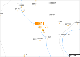
Ūshāb (Sīstān va Balūchestān, Iran)Ūshāb is a town in the Sīstān va Balūchestān region of Iran. An overview map of the region around Ūshāb is displayed below.
regional and 3d topo map of Ūshāb, Iran ::
Ūshāb airports ::
The nearest airport is ZBR - Chah Bahar, located 81.7 km south west of Ūshāb.
Other airports nearby include GWD - Gwadar (165.4 km south east), Nearby towns ::
Kohan-e Pā'īn (0.0km north) //
Kahn-e Pā'īn (1.2km east) //
Kahn-e Pā'īn (1.3km east) //
Ūshāb (2.3km south east) //
Kollānzeh (2.5km south east) //
Kahn-e Bālā (3.1km north west) //
Kahnak (5.6km south) //
Būrīdūk (6.0km south east) //
Kahn (6.2km south) //
Sar Tāp (7.5km north east) //
Mājeh (10.6km north west) //
[all distances 'as the bird flies' and approximate] 
Disclaimer :: Information on this page comes without warranty of any kind |
||
|
Where is Ūshāb? Elevation and coordinates ::
Latitude (lat): 26°0'0"N Longitude (lon): 60°55'0"E
Elevation (approx.): 211m (map arrows pan, magnifying glasses zoom) |
||
|
Visiting Ūshāb? Hotel/Accommodation ::
Book a hotel in Ūshāb Travel Guide ::
Buy a travel guide for Iran rental cars ::
car rental offers GPS waypoint ::
download a GPX waypoint (PoI) of Ūshāb for your GPS receiver
|
||