|
search place name
|
||
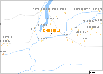
Chotiāli (Balochistān, Pakistan)Chotiāli is a town in the Balochistān region of Pakistan. An overview map of the region around Chotiāli is displayed below.
regional and 3d topo map of Chotiāli, Pakistan ::
Chotiāli airports ::
The nearest airport is SUL - Sui, located 156.2 km south of Chotiāli.
Other airports nearby include PZH - Zhob (156.5 km north), UET - Quetta (190.6 km west), RYK - Rahim Yar Khan Sheikh Zayed (226.8 km south east), Nearby towns ::
Doda Shahr (1.9km north east) //
Nasīr Khān (3.3km south west) //
Mānzkai Kili (4.3km north west) //
Nimki (4.6km north) //
Gumbaz (4.8km east) //
Ālam Shaikh (5.9km north) //
Alif Kili (5.2km east) //
Alif Kili (5.7km west) //
Dost Ali Ustrāni Shahr (6.3km north west) //
Nauroz Khān Kili (7.6km north) //
Īsāzai Kili (7.0km north east) //
Akhtar Shāh (6.9km east) //
Shāhābād (8.3km north) //
Mīr Khān Kili (9.6km north east) //
[all distances 'as the bird flies' and approximate] 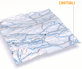 Places with similar names to Chotiāli, Pakistan ::
Disclaimer :: Information on this page comes without warranty of any kind |
||
|
Where is Chotiāli? Elevation and coordinates ::
Latitude (lat): 30°2'0"N Longitude (lon): 68°54'0"E
Elevation (approx.): 933m (map arrows pan, magnifying glasses zoom) |
||
|
Visiting Chotiāli? Hotel/Accommodation ::
Book a hotel in Chotiāli Travel Guide ::
Buy a travel guide for Pakistan rental cars ::
car rental offers GPS waypoint ::
download a GPX waypoint (PoI) of Chotiāli for your GPS receiver
|
||