|
search place name
|
||
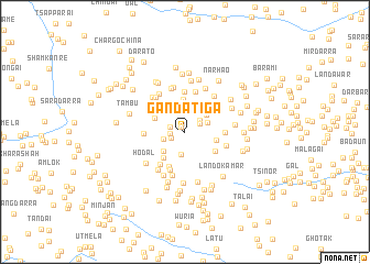
Ganda Tiga (Federally Administered Tribal Areas, Pakistan)Ganda Tiga is a town in the Federally Administered Tribal Areas region of Pakistan. An overview map of the region around Ganda Tiga is displayed below.
regional and 3d topo map of Ganda Tiga, Pakistan ::
Ganda Tiga airports ::
The nearest airport is JAA - Jalalabad, located 70.5 km north of Ganda Tiga.
Other airports nearby include PEW - Peshawar Intl (83.7 km east), KBL - Kabul Intl (158.7 km north west), SDT - Saidu Sharif (194.6 km north east), Nearby towns ::
Khaze Kunj (0.6km north west) //
Boi Nmasai (1.2km west) //
Sari Garhi (1.3km south west) //
Zarkhazai (1.4km west) //
Udal (1.5km north east) //
Nazar Kar (1.7km north east) //
Soi Garhi (1.9km south west) //
Alizai (2.3km south) //
Sinala (2.1km north east) //
Krumbai (2.5km north east) //
Bram Kadai (2.6km south west) //
Ghulbai (3.2km north) //
Chirai (2.8km east) //
Yakh Kamar (2.9km north west) //
Karappa (3.2km south west) //
Mulliāno Kili (3.1km north east) //
Ghurghushto Pail (3.2km south east) //
Aingara (3.8km south) //
Wali Nmasai (4.0km south) //
Tāpūgān (3.4km east) //
Akal Khel (4.1km north) //
Shawai Pīla Khel (3.9km south west) //
Lolat Kats (4.2km north) //
Haiki Kadda (3.5km west) //
Tapanai (3.7km east) //
Spedār (4.5km south) //
Mastj Khel (4.6km north) //
Ram Sher Khel (4.4km north west) //
Durbi Khel (4.3km north west) //
[all distances 'as the bird flies' and approximate]  Places with similar names to Ganda Tiga, Pakistan ::
// Candatag (PH)
// Cantatoc (PH)
// Cañada de Agua (CU)
// Gantodoga (BF)
// Gondodougou (GN)
// Koinétédiouaga (TG)
// Cañada de Agua (DO)
// Gondodougou (CI)
// Gouèndiédougou (CI)
// Kounadidougou (CI)
Disclaimer :: Information on this page comes without warranty of any kind |
||
|
Where is Ganda Tiga? Elevation and coordinates ::
Latitude (lat): 33°46'36"N Longitude (lon): 70°38'52"E
Elevation (approx.): 2378m (map arrows pan, magnifying glasses zoom) |
||
|
Visiting Ganda Tiga? Hotel/Accommodation ::
Book a hotel in Ganda Tiga Travel Guide ::
Buy a travel guide for Pakistan rental cars ::
car rental offers GPS waypoint ::
download a GPX waypoint (PoI) of Ganda Tiga for your GPS receiver
|
||