|
search place name
|
||
Shāmlāt (North-West Frontier, Pakistan)Shāmlāt is a town in the North-West Frontier region of Pakistan. An overview map of the region around Shāmlāt is displayed below.
regional and 3d topo map of Shāmlāt, Pakistan ::

Shāmlāt airports ::
The nearest airport is PEW - Peshawar Intl, located 47.3 km south west of Shāmlāt.
Other airports nearby include SDT - Saidu Sharif (74.2 km north east), ISB - Islamabad Chaklala (128.6 km south east), JAA - Jalalabad (132.8 km west), MFG - Muzaffarabad (145.8 km east), Nearby towns ::
Asghar Ali Korūna (0.7km north west) //
Sāzu Kili (1.2km north) //
Ghata Jhamra (1.1km north east) //
Ghāntol Kili (1.2km east) //
Zandai Kili (1.5km north) //
Bedo (1.4km east) //
Sattar Khan Mūhmand Kili (1.7km north) //
Miān Gul (1.9km north) //
Kandar Kili (1.7km north west) //
Azim Khān Korūna (2.0km south west) //
Kaudare (2.1km south east) //
Nāib Khān Korūna (2.1km north west) //
Kopar (2.3km north) //
Sari (2.1km south west) //
Nawe Kaudare (2.3km south east) //
Anwar Khān Korūna (2.6km south) //
Sāri Bahlol (2.4km north east) //
Firozpur (2.7km south west) //
Kāmrān (2.9km north) //
Shāh Beg (2.8km south east) //
Khattak Narai (2.5km north west) //
Muhammad Ismāīl Korūna (2.7km north west) //
Moghal Kili (2.5km west) //
Sāduddin (2.8km north east) //
Abdul Matīn (3.0km north) //
Ajun Kili (3.0km south west) //
Mīr Jān (2.8km north west) //
Hindu Kili (3.4km north) //
Sherdil Khān Korūna (3.4km south) //
[all distances 'as the bird flies' and approximate] 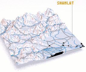 Places with similar names to Shāmlāt, Pakistan ::
// Chemult (US)
// Chamalito (CO)
// Chimalito (MX)
// Shām Buldi (PK)
// Shāmilat (PK)
// Shāmilāt (PK)
// Chumelito (HN)
// Shumba Alto (PE)
// Shumuultay (MN)
// Chamblet (FR)
Disclaimer :: Information on this page comes without warranty of any kind |
||
|
Where is Shāmlāt? Elevation and coordinates ::
Latitude (lat): 34°14'38"N Longitude (lon): 71°55'46"E
Elevation (approx.): 333m (map arrows pan, magnifying glasses zoom) |
||
|
Visiting Shāmlāt? Hotel/Accommodation ::
Book a hotel in Shāmlāt Travel Guide ::
Buy a travel guide for Pakistan rental cars ::
car rental offers GPS waypoint ::
download a GPX waypoint (PoI) of Shāmlāt for your GPS receiver
|
||