|
search place name
|
||
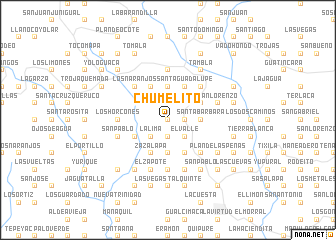
Chumelito (Lempira, Honduras)Chumelito is a town in the Lempira region of Honduras. An overview map of the region around Chumelito is displayed below.
regional and 3d topo map of Chumelito, Honduras ::
Chumelito airports ::
The nearest airport is SAL - San Salvador El Salvador Intl, located 85.1 km south west of Chumelito.
Other airports nearby include TGU - Tegucigalpa Toncontin Intl (165.8 km east), SAP - San Pedro Sula La Mesa Intl (169.4 km north east), GUA - Guatemala City La Aurora (197.6 km west), TEA - Tela (226.2 km north east), Nearby towns ::
Mescalares (0.0km north) //
Portillo del Aguacate (1.9km south) //
Los Limones (1.9km north) //
Chaparral (1.9km north) //
El Cerro (1.9km north) //
Avanzada (1.9km north) //
Valladolid (1.8km east) //
San Jerónimo (1.8km east) //
La Lima (2.6km south west) //
Portillo del Fraile (2.6km south west) //
El Repastadero (2.6km north west) //
El Valle (2.6km south east) //
Laja Blanca (3.6km east) //
Santa Bárbara (3.6km east) //
Cerro Grande (3.7km north) //
El Rodeo (3.7km south) //
Las Pulgas (4.0km north east) //
Amates (4.0km south west) //
Santa Guadalupe (4.1km north east) //
Las Cuevas (4.1km north west) //
Zazalapa (4.1km south west) //
Jocomico (4.1km south east) //
Chinquín (4.1km south west) //
Chaparrón (4.1km south west) //
Quequesques (4.1km south west) //
Piedra del Tigre (4.1km south east) //
Los Naranjos (5.2km north west) //
El Rodeo (5.2km north east) //
El Portillo (5.2km north east) //
[all distances 'as the bird flies' and approximate]  Places with similar names to Chumelito, Honduras ::
// Chemult (US)
// Chamalito (CO)
// Chimalito (MX)
// Shām Buldi (PK)
// Shāmilat (PK)
// Shāmilāt (PK)
// Shāmlāt (PK)
// Shumba Alto (PE)
// Shumuultay (MN)
// Chamblet (FR)
Disclaimer :: Information on this page comes without warranty of any kind |
||
|
Where is Chumelito? Elevation and coordinates ::
Latitude (lat): 14°9'0"N Longitude (lon): 88°45'0"W
Elevation (approx.): 956m (map arrows pan, magnifying glasses zoom) |
||
|
Visiting Chumelito? Hotel/Accommodation ::
Book a hotel in Chumelito Travel Guide ::
Buy a travel guide for Honduras rental cars ::
car rental offers GPS waypoint ::
download a GPX waypoint (PoI) of Chumelito for your GPS receiver
|
||