|
search place name
|
||
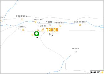
Tamba (Balochistān, Pakistan)Tamba is a town in the Balochistān region of Pakistan. An overview map of the region around Tamba is displayed below.
regional and 3d topo map of Tamba, Pakistan ::
Tamba airports ::
The nearest airport is TRB - Turbo Turbat Intl, located 5.2 km west of Tamba.
Other airports nearby include PSI - Pasni (80.4 km south), GWD - Gwadar (111.6 km south west), PJG - Panjgur (150.9 km north east), Nearby towns ::
Āb-i-Sar (2.7km north) //
Shaihāni Bāzār (4.0km north west) //
Yusak (4.4km north) //
Turbat (4.2km north west) //
Humbidār (4.9km north east) //
Mullāi Bāzār (5.2km north west) //
Sirī Kahn (6.7km north west) //
Gishtang (6.4km west) //
Bog (7.7km north west) //
Serias (9.5km south east) //
[all distances 'as the bird flies' and approximate] 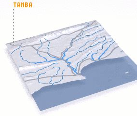 Places with similar names to Tamba, Pakistan ::
Disclaimer :: Information on this page comes without warranty of any kind |
||
|
Where is Tamba? Elevation and coordinates ::
Latitude (lat): 25°58'33"N Longitude (lon): 63°4'49"E
Elevation (approx.): 174m (map arrows pan, magnifying glasses zoom) |
||
|
Visiting Tamba? Hotel/Accommodation ::
Book a hotel in Tamba Travel Guide ::
Buy a travel guide for Pakistan rental cars ::
car rental offers GPS waypoint ::
download a GPX waypoint (PoI) of Tamba for your GPS receiver
|
||