|
search place name
|
||
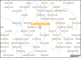
Cerro Negro (Copán, Honduras)Cerro Negro is a town in the Copán region of Honduras. An overview map of the region around Cerro Negro is displayed below.
regional and 3d topo map of Cerro Negro, Honduras ::
Cerro Negro airports ::
The nearest airport is SAL - San Salvador El Salvador Intl, located 118.9 km south of Cerro Negro.
Other airports nearby include SAP - San Pedro Sula La Mesa Intl (146.3 km north east), GUA - Guatemala City La Aurora (179.2 km west), TGU - Tegucigalpa Toncontin Intl (184.5 km east), CBV - Coban (197.3 km north west), Nearby towns ::
El Matasano (0.0km north) //
El Cajón (1.9km south) //
Amatillo (1.8km east) //
Gualme (2.6km north east) //
Palos Blancos (2.6km south east) //
El Plan de los Plátanos (3.7km north) //
La Cebadilla (3.6km west) //
La Calera (4.1km south west) //
Loma Casita (4.1km north west) //
Paso La Vaca (4.1km north west) //
Joya de Cones (4.1km north west) //
Yargüera (4.1km north east) //
Santa Marta (4.1km south east) //
San Francisco de Cones (4.0km north west) //
La Loma (4.0km south west) //
Las Mesitas (4.0km south west) //
El Membrillo (5.4km west) //
Naranjos (5.6km north) //
Guayabito (5.6km north) //
El Salitre (5.6km north) //
El Carrizal (5.6km north) //
Pitarrillo (5.6km north) //
El Naranjo (5.8km south) //
Cerro de Minas (5.8km north) //
Los Mangos (5.8km north) //
Potrerillos (5.7km west) //
San Francisco (5.7km west) //
Cruz Alta (5.7km east) //
Azacualpa (5.7km west) //
[all distances 'as the bird flies' and approximate] 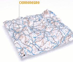 Places with similar names to Cerro Negro, Honduras ::
// Serra Negra (BR)
// Serra Negra (BR)
// Serra Negra (BR)
// Serra Negra (BR)
// Serra Negra (BR)
// Cerro Negro (PA)
// Cerro Negro (PA)
// Sŭrnegor (BG)
// Cernicari (RO)
// Srīnagar (BD)
Disclaimer :: Information on this page comes without warranty of any kind |
||
|
Where is Cerro Negro? Elevation and coordinates ::
Latitude (lat): 14°30'0"N Longitude (lon): 88°52'0"W
Elevation (approx.): 1407m (map arrows pan, magnifying glasses zoom) |
||
|
Visiting Cerro Negro? Hotel/Accommodation ::
Book a hotel in Cerro Negro Travel Guide ::
Buy a travel guide for Honduras rental cars ::
car rental offers GPS waypoint ::
download a GPX waypoint (PoI) of Cerro Negro for your GPS receiver
|
||