|
search place name
|
||
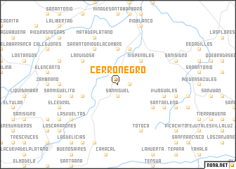
Cerro Negro (Santa Bárbara, Honduras)Cerro Negro is a town in the Santa Bárbara region of Honduras. An overview map of the region around Cerro Negro is displayed below.
regional and 3d topo map of Cerro Negro, Honduras ::
Cerro Negro airports ::
The nearest airport is SAP - San Pedro Sula La Mesa Intl, located 76.9 km north east of Cerro Negro.
Other airports nearby include TEA - Tela (136.4 km north east), TGU - Tegucigalpa Toncontin Intl (185.1 km south east), SAL - San Salvador El Salvador Intl (193.3 km south), LCE - La Ceiba Goloson Intl (194.9 km east), Nearby towns ::
La Unión (1.9km north) //
Las Delicias (1.9km north) //
San Miguel (1.9km south) //
Santa Elena (1.8km east) //
La Quebrada (2.6km north west) //
La Hacienda (2.6km north west) //
Nisperales (5.2km north east) //
El Cacao (5.6km north) //
Palma Real (5.7km west) //
El Guanacaste (5.8km north) //
Chiqueros (5.8km north) //
La Ruidosa (6.5km north west) //
San Antonio de la Cumbre (6.6km north west) //
Portillo del Tigre (6.5km south east) //
Aguacatales (6.5km south east) //
El Jardín (6.5km south east) //
Palmira (6.5km south east) //
Caobanales (7.4km east) //
El Playón (7.4km east) //
Vijaguales (7.4km east) //
El Triunfo (7.4km west) //
Los Cerrados (7.4km east) //
Mata de Plátano (8.2km north west) //
Totoca (8.2km south east) //
Agua Buena (8.1km south east) //
El Caracol (8.1km south east) //
Santa Elena (8.1km south east) //
Las Vueltas (9.1km south west) //
El Corozal (9.1km south west) //
[all distances 'as the bird flies' and approximate]  Places with similar names to Cerro Negro, Honduras ::
// Serra Negra (BR)
// Serra Negra (BR)
// Serra Negra (BR)
// Serra Negra (BR)
// Serra Negra (BR)
// Cerro Negro (PA)
// Cerro Negro (PA)
// Sŭrnegor (BG)
// Cernicari (RO)
// Srīnagar (BD)
Disclaimer :: Information on this page comes without warranty of any kind |
||
|
Where is Cerro Negro? Elevation and coordinates ::
Latitude (lat): 15°7'0"N Longitude (lon): 88°33'0"W
Elevation (approx.): 738m (map arrows pan, magnifying glasses zoom) |
||
|
Visiting Cerro Negro? Hotel/Accommodation ::
Book a hotel in Cerro Negro Travel Guide ::
Buy a travel guide for Honduras rental cars ::
car rental offers GPS waypoint ::
download a GPX waypoint (PoI) of Cerro Negro for your GPS receiver
|
||