|
search place name
|
||
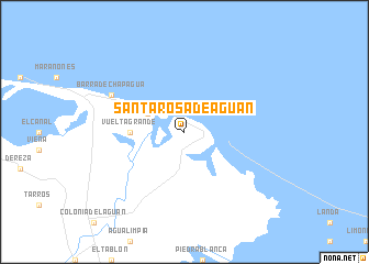
Santa Rosa de Aguán (Colón, Honduras)Santa Rosa de Aguán is a town in the Colón region of Honduras. An overview map of the region around Santa Rosa de Aguán is displayed below.
regional and 3d topo map of Santa Rosa de Aguán, Honduras ::
Santa Rosa de Aguán airports ::
The nearest airport is GJA - Guanaja, located 58.5 km north of Santa Rosa de Aguán.
Other airports nearby include RTB - Roatan Juan Manuel Galvez Intl (95.3 km north west), LCE - La Ceiba Goloson Intl (123.9 km west), TEA - Tela (189.4 km west), TGU - Tegucigalpa Toncontin Intl (264.1 km south west), Nearby towns ::
Barra de Aguán (4.0km north west) //
Vuelta Grande (5.3km west) //
Barra de Chapagua (8.0km north west) //
[all distances 'as the bird flies' and approximate] 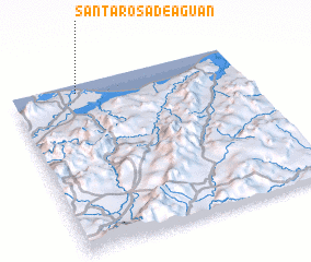 Places with similar names to Santa Rosa de Aguán, Honduras :: Disclaimer :: Information on this page comes without warranty of any kind |
||
|
Where is Santa Rosa de Aguán? Elevation and coordinates ::
Latitude (lat): 15°57'0"N Longitude (lon): 85°43'0"W
Elevation (approx.): 3m (map arrows pan, magnifying glasses zoom) |
||
|
Visiting Santa Rosa de Aguán? Hotel/Accommodation ::
Book a hotel in Santa Rosa de Aguán Travel Guide ::
Buy a travel guide for Honduras rental cars ::
car rental offers GPS waypoint ::
download a GPX waypoint (PoI) of Santa Rosa de Aguán for your GPS receiver
|
||