|
search place name
|
||
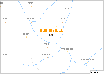
Huarasillo (Huánuco, Peru)Huarasillo is a town in the Huánuco region of Peru. An overview map of the region around Huarasillo is displayed below.
regional and 3d topo map of Huarasillo, Peru ::
Huarasillo airports ::
The nearest airport is ATA - Anta Comandante Fap German Arias Graziani, located 81.0 km south west of Huarasillo.
Other airports nearby include CHM - Chimbote Teniente Jaime A De Montreuil Morales (173.8 km west), JJI - Juanjui (204.0 km north), Nearby towns ::
Coro (4.1km south west) //
Quichiragra (4.1km north east) //
Cayán (6.7km north east) //
Chingas (7.6km south) //
Rondobamba (7.8km south east) //
Acobamba (9.2km north west) //
[all distances 'as the bird flies' and approximate] 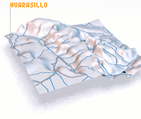 Places with similar names to Huarasillo, Peru ::
// Harsīlē (ER)
// Hirzel (CH)
// Hersel (DE)
// Hirzlei (DE)
// Harzalah (IQ)
// Ḩayy ar Risālah (IQ)
// Herrezuelo (ES)
// Harsail (BD)
// Harisal (IN)
// Harsauli (IN)
Disclaimer :: Information on this page comes without warranty of any kind |
||
|
Where is Huarasillo? Elevation and coordinates ::
Latitude (lat): 9°0'0"S Longitude (lon): 76°57'0"W
Elevation (approx.): 4231m (map arrows pan, magnifying glasses zoom) |
||
|
Visiting Huarasillo? Hotel/Accommodation ::
Book a hotel in Huarasillo Travel Guide ::
Buy a travel guide for Peru rental cars ::
car rental offers GPS waypoint ::
download a GPX waypoint (PoI) of Huarasillo for your GPS receiver
|
||