|
search place name
|
||
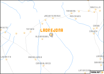
La Orejona (Piura, Peru)La Orejona is a town in the Piura region of Peru. An overview map of the region around La Orejona is displayed below.
regional and 3d topo map of La Orejona, Peru ::
La Orejona airports ::
The nearest airport is TYL - Talara Capitan Montes, located 41.8 km west of La Orejona.
Other airports nearby include PIU - Piura Capitan Fap Guillermo Concha Iberico (63.2 km south east), TBP - Tumbes Pedro Canga (140.6 km north east), MCH - Machala General Manuel Serrano (190.6 km north east), CUE - Cuenca Mariscal Lamar (293.2 km north east), Nearby towns ::
Algarrobal (3.5km west) //
Quebrada Grande (6.0km north west) //
Quebrada Honda (6.6km north) //
Jaguay Grande (6.8km north) //
Totora (7.9km west) //
Pampa Larga (10.1km south west) //
Pescados (10.7km north east) //
Tambara (11.0km north east) //
[all distances 'as the bird flies' and approximate] 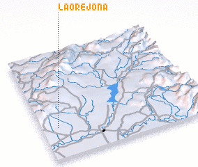 Places with similar names to La Orejona, Peru ::
// La Región (CU)
// Largino (RU)
// Lorgino (RU)
// La Regina (CO)
// La Regina (MX)
// Lārījān (IR)
// Lorījān (IR)
// Larajani (PE)
// La Orejana (VE)
// La Orejana (VE)
Disclaimer :: Information on this page comes without warranty of any kind |
||
|
Where is La Orejona? Elevation and coordinates ::
Latitude (lat): 4°42'40"S Longitude (lon): 80°54'7"W
Elevation (approx.): 285m (map arrows pan, magnifying glasses zoom) |
||
|
Visiting La Orejona? Hotel/Accommodation ::
Book a hotel in La Orejona Travel Guide ::
Buy a travel guide for Peru rental cars ::
car rental offers GPS waypoint ::
download a GPX waypoint (PoI) of La Orejona for your GPS receiver
|
||