|
search place name
|
||
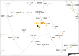
Santos (Piura, Peru)Santos is a town in the Piura region of Peru. An overview map of the region around Santos is displayed below.
regional and 3d topo map of Santos, Peru ::
Santos airports ::
The nearest airport is PIU - Piura Capitan Fap Guillermo Concha Iberico, located 61.7 km west of Santos.
Other airports nearby include TYL - Talara Capitan Montes (156.5 km north west), CIX - Chiclayo Capt Jose A Quinones Gonzales Intl (159.6 km south), TBP - Tumbes Pedro Canga (203.3 km north), Nearby towns ::
Caserio de Los Silva (0.6km south west) //
Ternique (3.7km east) //
El Setentiséis (4.0km north) //
Noria Zapata (5.2km south west) //
Monte Azul (6.7km north) //
Colpas (7.3km east) //
Punta Arena (7.6km south) //
Silva (7.6km west) //
Hualtaco (7.8km south east) //
Hispón (8.0km north west) //
Laguna Mariana (8.8km south) //
[all distances 'as the bird flies' and approximate]  Places with similar names to Santos, Peru ::
Disclaimer :: Information on this page comes without warranty of any kind |
||
|
Where is Santos? Elevation and coordinates ::
Latitude (lat): 5°22'0"S Longitude (lon): 80°5'0"W
Elevation (approx.): 162m (map arrows pan, magnifying glasses zoom) |
||
|
Visiting Santos? Hotel/Accommodation ::
Book a hotel in Santos Travel Guide ::
Buy a travel guide for Peru rental cars ::
car rental offers GPS waypoint ::
download a GPX waypoint (PoI) of Santos for your GPS receiver
|
||