|
search place name
|
||
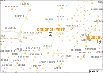
Agua Caliente (Sucre, Venezuela)Agua Caliente is a town in the Sucre region of Venezuela. An overview map of the region around Agua Caliente is displayed below.
regional and 3d topo map of Agua Caliente, Venezuela ::
Agua Caliente airports ::
The nearest airport is CUP - Carupano General Jose Francisco Bermudez, located 27.9 km north east of Agua Caliente.
Other airports nearby include PMV - Porlamar Del Caribe Intl Gen Santiago Marino (73.5 km north west), CUM - Cumana Antonio Jose De Sucre (74.6 km west), MUN - Maturin (88.1 km south), GUI - Guiria (124.8 km east), Nearby towns ::
Chandia (2.7km east) //
El Banqueado (3.1km east) //
Casanay (3.8km east) //
Arenas (3.9km east) //
La Funcia (4.5km south) //
La Cruz de Santa Marta (5.0km north east) //
Cerro de Piedra Afuera (5.4km south east) //
El Costo (5.4km north) //
Los Apamates (5.7km north) //
Las Varas (5.8km east) //
Nueva Aldea (5.8km east) //
Los Pozos Afuera (6.1km south) //
La Pica (6.4km south) //
Los Pozos Adentro (6.7km south west) //
Cedeño de Los Negros (6.8km east) //
Quebrada de Tigre Adentro (6.9km west) //
Carrizal de La Cruz (6.9km west) //
Los Rastrojos (7.2km south) //
La Ladera (7.2km south east) //
La Perla (7.2km south) //
El Mayal (7.3km north east) //
Las Minas (7.5km south east) //
Las Toscanas (7.5km east) //
Quebrada de Tigre (7.5km west) //
Corozal de las Tablas (7.8km east) //
Pueblo Viejo (7.9km north east) //
Saca Manteca (8.2km south west) //
La Laguna (8.1km east) //
Alto de La Cruz (8.4km south west) //
[all distances 'as the bird flies' and approximate]  Places with similar names to Agua Caliente, Venezuela ::
// Agua Caliente (BO)
// Agua Caliente (BO)
// Agua Caliente (BO)
// Agua Caliente (BO)
// Agua Caliente (US)
// Agua Caliente (US)
// Agua Caliente (PA)
// Agua Caliente (CO)
// Agua Caliente (CO)
// Aguacaliente (CO)
Disclaimer :: Information on this page comes without warranty of any kind |
||
|
Where is Agua Caliente? Elevation and coordinates ::
Latitude (lat): 10°29'22"N Longitude (lon): 63°27'0"W
Elevation (approx.): 33m (map arrows pan, magnifying glasses zoom) |
||
|
Visiting Agua Caliente? Hotel/Accommodation ::
Book a hotel in Agua Caliente Travel Guide ::
Buy a travel guide for Venezuela rental cars ::
car rental offers GPS waypoint ::
download a GPX waypoint (PoI) of Agua Caliente for your GPS receiver
|
||