|
search place name
|
||
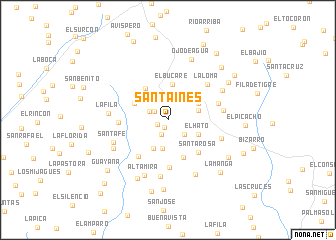
Santa Inés (Lara, Venezuela)Santa Inés is a town in the Lara region of Venezuela. An overview map of the region around Santa Inés is displayed below.
regional and 3d topo map of Santa Inés, Venezuela ::
Santa Inés airports ::
The nearest airport is GUQ - Guanare, located 53.3 km south of Santa Inés.
Other airports nearby include AGV - Acarigua Oswaldo Guevara Mujica (58.6 km east), BRM - Barquisimeto Intl (74.3 km north east), VLV - Valera Dr Antonio Nicolas Briceno (91.4 km west), BNS - Barinas (110.1 km south west), Nearby towns ::
Quebrada Arriba (0.9km south west) //
Valle Hondo (1.3km south west) //
Los Nuezales (1.8km south) //
Villa Nueva (1.8km north west) //
La Vigía (2.3km north west) //
El Rincón (2.4km north) //
Potrerito de Manzano (2.5km south east) //
Palo Grande (3.0km north east) //
Buena Vista (3.2km south) //
San Isidro (3.5km south west) //
Cerro Gordo (3.6km east) //
El Hato (3.8km south east) //
El Caura (3.9km north east) //
El Bucare (4.1km north) //
Tamboral (4.1km north west) //
Villanueva (4.3km north west) //
Mariloncita (4.5km south) //
Santa Rosa (5.0km south east) //
Los Monos (5.2km south west) //
Marilonza (5.3km south) //
Los Puentes (5.5km west) //
La Loma (5.9km north east) //
Volcancito (5.9km east) //
Volcán Grande (6.3km east) //
Las Barrancas (6.3km east) //
Barrio Nuevo (6.4km south) //
Santa Fe (6.5km west) //
La Fila (6.6km west) //
Altamira (6.7km south west) //
[all distances 'as the bird flies' and approximate] 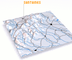 Places with similar names to Santa Inés, Venezuela ::
// Santa Inês (BR)
// Santa Inês (BR)
// Santa Inês (BR)
// Santo Inácio (BR)
// Santo Inácio (BR)
// Santo Inácio (BR)
// Santo Inácio (BR)
// Santo Inácio (BR)
// Santo Inácio (BR)
// Santa Ynez (US)
Disclaimer :: Information on this page comes without warranty of any kind |
||
|
Where is Santa Inés? Elevation and coordinates ::
Latitude (lat): 9°30'30"N Longitude (lon): 69°46'10"W
Elevation (approx.): 1124m (map arrows pan, magnifying glasses zoom) |
||
|
Visiting Santa Inés? Hotel/Accommodation ::
Book a hotel in Santa Inés Travel Guide ::
Buy a travel guide for Venezuela rental cars ::
car rental offers GPS waypoint ::
download a GPX waypoint (PoI) of Santa Inés for your GPS receiver
|
||