|
search place name
|
||
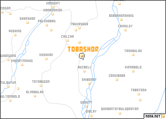
Tobashor ((( Kulyabskaya Oblast' )), Tajikistan)Tobashor is a town in the (( Kulyabskaya Oblast' )) region of Tajikistan. An overview map of the region around Tobashor is displayed below.
regional and 3d topo map of Tobashor, Tajikistan ::
Tobashor airports ::
The nearest airport is DYU - Dushanbe, located 79.8 km north west of Tobashor.
Other airports nearby include UND - Kunduz Konduz (174.2 km south), Nearby towns ::
Jantokli (1.8km north) //
Buzbeli (2.7km south) //
Davatkhalqaer (3.9km north) //
Chilcha (5.1km north west) //
Shibonay (5.6km south) //
Devona (6.7km north) //
Yakkasada (7.1km north) //
Kushkak (6.6km west) //
Zangi-Baba (7.5km south east) //
Alʼmabulak (8.7km north west) //
Falkhabad (10.1km north west) //
[all distances 'as the bird flies' and approximate] 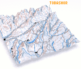 Places with similar names to Tobashor, Tajikistan ::
Disclaimer :: Information on this page comes without warranty of any kind |
||
|
Where is Tobashor? Elevation and coordinates ::
Latitude (lat): 38°8'26"N Longitude (lon): 69°34'52"E
Elevation (approx.): 982m (map arrows pan, magnifying glasses zoom) |
||
|
Visiting Tobashor? Hotel/Accommodation ::
Book a hotel in Tobashor Travel Guide ::
Buy a travel guide for Tajikistan rental cars ::
car rental offers GPS waypoint ::
download a GPX waypoint (PoI) of Tobashor for your GPS receiver
|
||