|
search place name
|
||
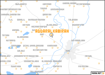
Ad Dār al Kabīrah (Ḩimş, Syria)Ad Dār al Kabīrah is a town in the Ḩimş region of Syria. An overview map of the region around Ad Dār al Kabīrah is displayed below.
regional and 3d topo map of Ad Dār al Kabīrah, Syria ::
Ad Dār al Kabīrah airports ::
The nearest airport is LTK - Latakia Bassel Al Assad Intl, located 94.8 km north west of Ad Dār al Kabīrah.
Other airports nearby include BEY - Beirut Rafic Hariri Intl (152.2 km south west), DAM - Damascus Intl (152.9 km south), PMS - Palmyra (153.3 km east), ALP - Aleppo Intl (163.1 km north), Nearby towns ::
Al Ghāşibīyah (1.6km south) //
Hubūb ar Rīḩ (2.2km north) //
Kharkhar (3.7km south) //
Al Ḩalamūz (3.7km north) //
Rām (3.1km west) //
Ad Duwayr (4.0km south) //
Ţayr Ma‘lah (3.6km north east) //
Al Rhannto (3.6km north east) //
Mazra‘at Rafqīn (4.9km north west) //
Sunaysil (4.9km west) //
Umm al Qaşşāb (5.9km south west) //
Az Zarzūrīyah (6.3km south west) //
Rafīn (6.4km west) //
Qanāyah (7.6km north) //
Akrād Dayāsinah (7.2km north west) //
Ḩimş (7.2km south east) //
Shālūḩ (8.0km south) //
Talbīsah (8.2km north east) //
[all distances 'as the bird flies' and approximate]  Places with similar names to Ad Dār al Kabīrah, Syria :: Disclaimer :: Information on this page comes without warranty of any kind |
||
|
Where is Ad Dār al Kabīrah? Elevation and coordinates ::
Latitude (lat): 34°47'0"N Longitude (lon): 36°40'0"E
Elevation (approx.): 477m (map arrows pan, magnifying glasses zoom) |
||
|
Visiting Ad Dār al Kabīrah? Hotel/Accommodation ::
Book a hotel in Ad Dār al Kabīrah Travel Guide ::
Buy a travel guide for Syria rental cars ::
car rental offers GPS waypoint ::
download a GPX waypoint (PoI) of Ad Dār al Kabīrah for your GPS receiver
|
||