|
search place name
|
||
Al Walīd (Al Ḩasakah, Syria)Al Walīd is a town in the Al Ḩasakah region of Syria. An overview map of the region around Al Walīd is displayed below.
regional and 3d topo map of Al Walīd, Syria ::

Al Walīd airports ::
The nearest airport is BAL - Batman, located 146.9 km north west of Al Walīd.
Other airports nearby include VAN - Van (197.5 km north east), Nearby towns ::
Al Walīd (1.4km east) //
Quldmān (3.8km north west) //
As Suwaydīyah (5.2km north west) //
Maḩmūdīyah (6.9km south) //
Qal‘at al Ḩişn (6.6km north east) //
Tall Khinzīr Taḩtānī (7.1km north) //
Tall Khinzīr Fawqānī (7.2km north) //
Al Khuwaytilah (6.0km south west) //
Ḩammāmuk (7.8km north) //
Kalhī (6.5km north east) //
Khirbat al Biʼr (7.2km south west) //
Al Mushayrifah (8.4km south west) //
Sufāyah (10.0km south east) //
[all distances 'as the bird flies' and approximate] 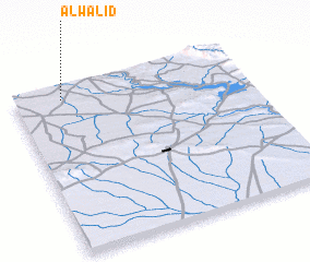 Places with similar names to Al Walīd, Syria ::
// Al Walīd (IQ)
Disclaimer :: Information on this page comes without warranty of any kind |
||
|
Where is Al Walīd? Elevation and coordinates ::
Latitude (lat): 36°55'50"N Longitude (lon): 42°12'20"E
Elevation (approx.): 444m (map arrows pan, magnifying glasses zoom) |
||
|
Visiting Al Walīd? Hotel/Accommodation ::
Book a hotel in Al Walīd Travel Guide ::
Buy a travel guide for Syria rental cars ::
car rental offers GPS waypoint ::
download a GPX waypoint (PoI) of Al Walīd for your GPS receiver
|
||