|
search place name
|
||
Shu‘bat Maskanah (Ḩalab, Syria)Shu‘bat Maskanah is a town in the Ḩalab region of Syria. An overview map of the region around Shu‘bat Maskanah is displayed below.
regional and 3d topo map of Shu‘bat Maskanah, Syria ::

Shu‘bat Maskanah airports ::
The nearest airport is ALP - Aleppo Intl, located 81.4 km west of Shu‘bat Maskanah.
Other airports nearby include GZT - Gaziantep Oguzeli (118.9 km north west), PMS - Palmyra (161.3 km south), Nearby towns ::
Maskanah (2.4km north west) //
As Samūmah (3.5km south east) //
As Salām ‘Alayk (4.0km north) //
Ḩawījat Isḩāq (4.0km north) //
Ḩardānah (3.7km south east) //
Raddat al Kabīrah (4.8km south east) //
Kasrat Muraybiţ (4.8km north east) //
Jaybiţ (5.6km north) //
Rasm al Ghazāl (4.9km west) //
Ju‘aybah (6.2km north) //
Masḩat aţ Ţurn (6.7km south) //
Muraybah (7.4km north) //
Muraybiţ (7.6km north) //
Mallāḩ (7.6km north) //
Abū Ḩasan (7.2km south east) //
Shanhaşah (7.1km south east) //
Al Ḩumr (7.0km north west) //
‘Aţshānat al Ḩumr (7.0km north west) //
Marqadah (8.2km south east) //
Jidā‘ Şaghīrah (9.4km south west) //
Khirbat al Ḩamrā (9.8km south west) //
[all distances 'as the bird flies' and approximate] 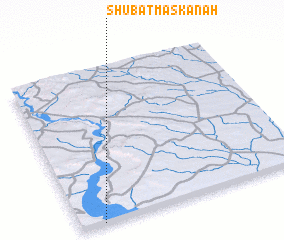 Places with similar names to Shu‘bat Maskanah, Syria :: Disclaimer :: Information on this page comes without warranty of any kind |
||
|
Where is Shu‘bat Maskanah? Elevation and coordinates ::
Latitude (lat): 36°0'0"N Longitude (lon): 38°6'0"E
Elevation (approx.): 302m (map arrows pan, magnifying glasses zoom) |
||
|
Visiting Shu‘bat Maskanah? Hotel/Accommodation ::
Book a hotel in Shu‘bat Maskanah Travel Guide ::
Buy a travel guide for Syria rental cars ::
car rental offers GPS waypoint ::
download a GPX waypoint (PoI) of Shu‘bat Maskanah for your GPS receiver
|
||