|
search place name
|
||
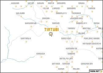
Timtubi (Gongola, Nigeria)Timtubi is a town in the Gongola region of Nigeria. An overview map of the region around Timtubi is displayed below.
regional and 3d topo map of Timtubi, Nigeria ::
Timtubi airports ::
The nearest airport is YOL - Yola, located 104.4 km north east of Timtubi.
Other airports nearby include GOU - Garoua (181.8 km north east), NGE - N'gaoundere Ngaoundere (208.1 km south east), Nearby towns ::
Gangkogoni (4.1km north east) //
Sansiri (4.1km north east) //
Sangasumi (5.8km east) //
Sangam (5.9km north) //
Sangyigmi (5.8km east) //
Numvan (6.7km north west) //
Ganye (7.6km east) //
Tapare (7.6km east) //
Lugere (7.6km east) //
Arnado Debbo (7.6km east) //
Sabon Layi (8.3km north east) //
Gurumpawa (8.2km north west) //
Shadugh (8.3km south west) //
Dafon (9.2km north east) //
Gangmuyen (9.2km north east) //
Wuro Hausa (9.2km south east) //
Sugu (9.2km south east) //
Gangweren (10.4km north east) //
Daboma (10.4km south east) //
[all distances 'as the bird flies' and approximate] 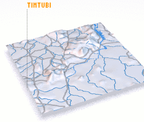 Places with similar names to Timtubi, Nigeria ::
// Tmat Baeuy (KH)
// Tambaytobe (KZ)
// Diama Toubé (SN)
// Toumi Diabi (ML)
// Dumbit 1 (PG)
// Diêm Tiêu (1) (VN)
// Tomtebo (SE)
// Tomteby (SE)
Disclaimer :: Information on this page comes without warranty of any kind |
||
|
Where is Timtubi? Elevation and coordinates ::
Latitude (lat): 8°25'0"N Longitude (lon): 12°0'0"E
Elevation (approx.): 519m (map arrows pan, magnifying glasses zoom) |
||
|
Visiting Timtubi? Hotel/Accommodation ::
Book a hotel in Timtubi Travel Guide ::
Buy a travel guide for Nigeria rental cars ::
car rental offers GPS waypoint ::
download a GPX waypoint (PoI) of Timtubi for your GPS receiver
|
||