|
search place name
|
||
Zagani (Gongola, Nigeria)Zagani is a town in the Gongola region of Nigeria. An overview map of the region around Zagani is displayed below.
regional and 3d topo map of Zagani, Nigeria ::

Zagani airports ::
The nearest airport is MIU - Maiduguri, located 210.5 km east of Zagani.
Nearby towns ::
Madeniye (2.6km south east) //
Garin Mallam Babai (3.6km east) //
Manawaji (4.1km north east) //
Jumaʼa Bubaram (4.1km south east) //
Baba Audu (5.7km east) //
Gabdan (5.8km south) //
Bade (5.8km south) //
Mainabijik (5.8km south) //
Lukunde (6.6km south west) //
Damcuwa (7.3km east) //
Shambayi (7.3km west) //
Shaibawa (7.6km north) //
Garin Lamido Shanu (7.5km east) //
Gamawa (7.6km south) //
Koliko (7.5km west) //
Abare (7.8km south east) //
Gaka (7.8km south east) //
Tikau (8.6km south west) //
Garin Mallam Haruna (9.2km north east) //
Bataba (9.1km south east) //
Gamaru (9.1km north west) //
Jakadi (9.1km south west) //
Gidgid (9.1km south west) //
Walu (9.2km south west) //
Alaraba (9.2km east) //
[all distances 'as the bird flies' and approximate] 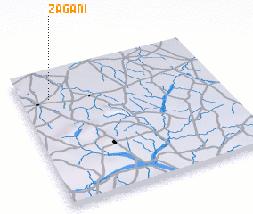 Places with similar names to Zagani, Nigeria ::
Disclaimer :: Information on this page comes without warranty of any kind |
||
|
Where is Zagani? Elevation and coordinates ::
Latitude (lat): 11°48'0"N Longitude (lon): 11°9'0"E
Elevation (approx.): 408m (map arrows pan, magnifying glasses zoom) |
||
|
Visiting Zagani? Hotel/Accommodation ::
Book a hotel in Zagani Travel Guide ::
Buy a travel guide for Nigeria rental cars ::
car rental offers GPS waypoint ::
download a GPX waypoint (PoI) of Zagani for your GPS receiver
|
||