|
search place name
|
||
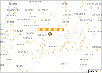
Chŏngja-dong (Kangwŏn, Korea, North)Chŏngja-dong is a town in the Kangwŏn region of Korea, North. An overview map of the region around Chŏngja-dong is displayed below.
regional and 3d topo map of Chŏngja-dong, Korea, North ::
Chŏngja-dong airports ::
The nearest airport is SHO - Sokch'o Sokcho, located 95.8 km east of Chŏngja-dong.
Other airports nearby include SSN - Seoul East Seoul Ab (113.0 km south), GMP - Seoul Gimpo (115.3 km south west), KAG - Kangnung Gangneung (141.6 km south east), OSN - Osan Ab (152.8 km south), Nearby towns ::
Chingmok-tong (0.8km south) //
Paegyang-ni (0.9km south west) //
Hoegogae (1.7km south east) //
Yul-dong (2.3km south) //
Kubong-ni (2.2km east) //
T'ap-kol (2.5km south west) //
Ŏdŏng-ni (2.6km west) //
Igan-dong (2.8km north east) //
Ŏch'ŏl-li (3.1km north west) //
Sinyang-dong (3.5km north) //
Sut'ae-ri (3.5km south west) //
Ach'im-ni (3.7km south west) //
Churach'i (4.4km south) //
Ch'osŏ-ri (3.8km north east) //
Namch'ŏngyo (3.7km north east) //
Hŭksal-li (4.0km north west) //
Samnam-ni (4.8km south) //
Sangsang-ni (4.1km north east) //
Chegung-dong (4.3km south west) //
Pyŏryang-ni (4.6km north east) //
Magaji (4.9km north) //
Minamri-gol (4.5km south west) //
Sogogae (4.6km north west) //
Huch'ŏl-li (4.2km east) //
Chŏnja-mal (4.4km south west) //
Chŏn-gol (4.7km south east) //
Kahyŏl-li (5.2km south west) //
Hagogae (4.7km south east) //
Namdul-li (4.9km south east) //
[all distances 'as the bird flies' and approximate] 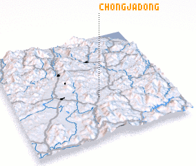 Places with similar names to Chŏngja-dong, Korea, North ::
// Changjae-dong (KP)
// Changjae-dong (KP)
// Changjae-dong (KP)
// Changjae-dong (KP)
// Changjae-dong (KP)
// Changjae-dong (KP)
// Changjae-dong (KP)
// Changjae-dong (KP)
// Chŏngja-dong (KP)
// Chŏngja-dong (KP)
Disclaimer :: Information on this page comes without warranty of any kind |
||
|
Where is Chŏngja-dong? Elevation and coordinates ::
Latitude (lat): 38°24'10"N Longitude (lon): 127°33'15"E
Elevation (approx.): 337m (map arrows pan, magnifying glasses zoom) |
||
|
Visiting Chŏngja-dong? Hotel/Accommodation ::
Book a hotel in Chŏngja-dong Travel Guide ::
rental cars ::
car rental offers GPS waypoint ::
download a GPX waypoint (PoI) of Chŏngja-dong for your GPS receiver
|
||