|
search place name
|
||
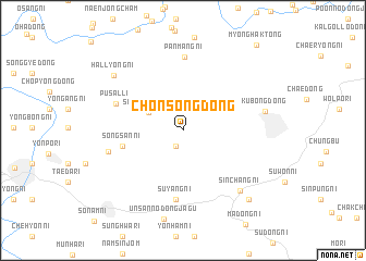
Ch'ŏnsŏng-dong (P'yŏngan, Korea, North)Ch'ŏnsŏng-dong is a town in the P'yŏngan region of Korea, North. An overview map of the region around Ch'ŏnsŏng-dong is displayed below.
regional and 3d topo map of Ch'ŏnsŏng-dong, Korea, North ::
Ch'ŏnsŏng-dong airports ::
The nearest airport is FNJ - Pyongyang Intl, located 44.9 km south west of Ch'ŏnsŏng-dong.
Other airports nearby include GMP - Seoul Gimpo (220.2 km south), Nearby towns ::
Kojŏng-ni (1.7km south) //
Songgan-dong (3.3km north west) //
Sŏngsan-ni (5.1km west) //
Suyang-ni (7.2km south) //
Pusal-li (6.0km north west) //
P'anmang-ni (7.6km north) //
Ŭnsan-ŭp (6.3km west) //
Sinch'ang-ni (7.7km south east) //
Kubong-dong (6.8km east) //
Hallyŏng-ni (7.8km north west) //
Mangil-li (8.8km south east) //
Myŏnghak-tong (10.5km north east) //
[all distances 'as the bird flies' and approximate] 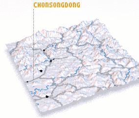 Places with similar names to Ch'ŏnsŏng-dong, Korea, North ::
// Chinsang-dong (KP)
// Chŏinsang-dong (KP)
// Ch'ŏnsang-dong (KP)
// Chŏnsŭng-dong (KP)
// Ch'ŏnsŏng-dong (KR)
// Ch'ŏnsang-dong (KP)
Disclaimer :: Information on this page comes without warranty of any kind |
||
|
Where is Ch'ŏnsŏng-dong? Elevation and coordinates ::
Latitude (lat): 39°27'51"N Longitude (lon): 126°5'22"E
Elevation (approx.): 227m (map arrows pan, magnifying glasses zoom) |
||
|
Visiting Ch'ŏnsŏng-dong? Hotel/Accommodation ::
Book a hotel in Ch'ŏnsŏng-dong Travel Guide ::
rental cars ::
car rental offers GPS waypoint ::
download a GPX waypoint (PoI) of Ch'ŏnsŏng-dong for your GPS receiver
|
||