|
search place name
|
||
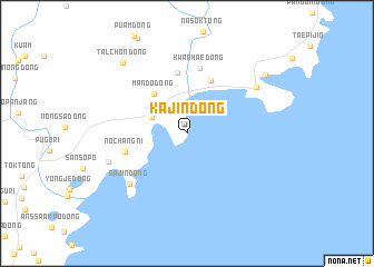
Kajin-dong (Hamgyŏng, Korea, North)Kajin-dong is a town in the Hamgyŏng region of Korea, North. An overview map of the region around Kajin-dong is displayed below.
regional and 3d topo map of Kajin-dong, Korea, North ::
Nearby towns ::
Sunam-dong (3.0km north west) //
Samhae-dong (3.9km north west) //
Mando-dong (4.7km north west) //
Soch'ŏng-dong (5.6km north) //
Changsan-dong (6.1km north) //
Noch'ang-ni (5.0km west) //
Kwanhae-dong (6.6km north) //
Sajin-dong (6.7km south west) //
Namnyang-dong (6.5km south west) //
Ijin-dong (7.0km north east) //
Talchŏn-dong (8.5km north west) //
Yŏngjin-dong (8.3km north east) //
[all distances 'as the bird flies' and approximate]  Places with similar names to Kajin-dong, Korea, North ::
// Kojan-dong (KP)
// Kojan-dong (KP)
// Kŏjin-dong (KP)
// Kujŏn-dong (KP)
// Kajin-dong (KR)
// Kojan-dong (KP)
Disclaimer :: Information on this page comes without warranty of any kind |
||
|
Where is Kajin-dong? Elevation and coordinates ::
Latitude (lat): 42°2'50"N Longitude (lon): 130°4'46"E
(map arrows pan, magnifying glasses zoom) |
||
|
Visiting Kajin-dong? Hotel/Accommodation ::
Book a hotel in Kajin-dong Travel Guide ::
rental cars ::
car rental offers GPS waypoint ::
download a GPX waypoint (PoI) of Kajin-dong for your GPS receiver
|
||