|
search place name
|
||
Sangp'ohang-ni (Yanggang, Korea, North)Sangp'ohang-ni is a town in the Yanggang region of Korea, North. An overview map of the region around Sangp'ohang-ni is displayed below.
regional and 3d topo map of Sangp'ohang-ni, Korea, North ::
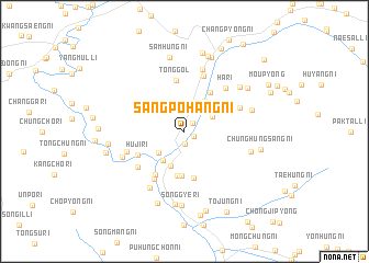
Nearby towns ::
Chungp'ohang-ni (0.8km south east) //
Samil-lodongjagu (1.0km north east) //
Hap'ohang-ni (1.3km south) //
Maeyang-gol (2.6km north east) //
Kubo-ri (2.9km north east) //
Hoeril-li (2.9km south west) //
Kyohang-ni (3.4km south west) //
Ŏyŏl-li (3.5km north east) //
Hwajang-ni (3.7km south) //
Taep'yŏng-ni (4.5km south) //
Taejung-ni (4.5km south) //
Sinp'ung-ni (4.4km north east) //
Yŏnp'ung-ni (4.8km south) //
Taep'yŏng-ni (4.9km south west) //
Tong-gol (5.2km north) //
Sinch'ang-ni (4.3km north east) //
Huji-ri (4.3km south west) //
Uha-ri (5.4km south west) //
Sinhŭng-ni (5.8km north) //
Huji-ri (5.1km south west) //
Yujŏng-ni (4.9km north east) //
Ha-ri (5.5km north east) //
Chungch'ŏl-li (4.9km south west) //
Hamjŏngp'o-ri (6.5km north) //
Usang-ni (6.4km south west) //
Chindul-li (5.4km south west) //
Chunghŭngha-ri (5.5km south east) //
Nŏltari-gol (5.6km north east) //
Sinjŏng-ni (6.2km north east) //
[all distances 'as the bird flies' and approximate] 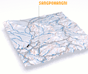 Places with similar names to Sangp'ohang-ni, Korea, North :: Disclaimer :: Information on this page comes without warranty of any kind |
||
|
Where is Sangp'ohang-ni? Elevation and coordinates ::
Latitude (lat): 41°11'57"N Longitude (lon): 128°15'32"E
Elevation (approx.): 809m (map arrows pan, magnifying glasses zoom) |
||
|
Visiting Sangp'ohang-ni? Hotel/Accommodation ::
Book a hotel in Sangp'ohang-ni Travel Guide ::
rental cars ::
car rental offers GPS waypoint ::
download a GPX waypoint (PoI) of Sangp'ohang-ni for your GPS receiver
|
||