|
search place name
|
||
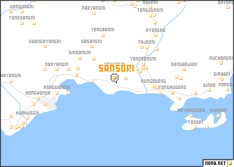
Sansŏ-ri (Hamgyŏng, Korea, North)Sansŏ-ri is a town in the Hamgyŏng region of Korea, North. An overview map of the region around Sansŏ-ri is displayed below.
regional and 3d topo map of Sansŏ-ri, Korea, North ::
Sansŏ-ri airports ::
The nearest airport is SHO - Sokch'o Sokcho, located 216.3 km south of Sansŏ-ri.
Nearby towns ::
Unp'o-rodongjagu (1.4km north east) //
Unhŭng-ni (2.2km north) //
Chungyang-ni (3.4km north east) //
Chunghŭng-ni (3.1km west) //
Sinp'ung-ni (3.5km north east) //
Yongjung-ni (4.1km north east) //
Yongsŏng-ni (4.5km north east) //
Chungdŏng-ni (4.4km north east) //
Unsang-ni (4.9km north west) //
P'ungŏ-dong (4.6km east) //
Yŏngdae-ri (5.0km east) //
Songnyŏng-ni (5.1km west) //
Kyŏnghŭng-ni (5.4km north west) //
Samsŏng-ni (6.6km north east) //
Sinsŏng-ni (6.1km north west) //
Sŏsang-ni (6.7km north west) //
Songnae (5.6km east) //
Tajŏn-ni (6.8km north east) //
Pangha-ri (6.1km west) //
Kyŏngp'o-ri (6.3km west) //
Yongban-ni (7.9km north) //
Ch'ŏnha-ri (7.4km north east) //
P'yŏngp'o (9.1km north east) //
[all distances 'as the bird flies' and approximate] 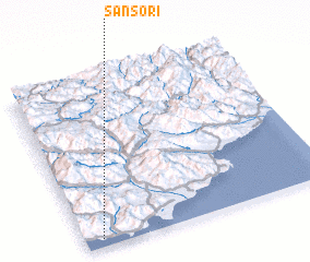 Places with similar names to Sansŏ-ri, Korea, North ::
// Sonasar (AZ)
// San Nazzaro (CH)
// Zinzer (US)
// San Nazario (IT)
// San Nazzaro (IT)
// San Nazzaro (IT)
// San Siro (IT)
// San Siro (IT)
// Sînişor (RO)
// Sansar (TR)
Disclaimer :: Information on this page comes without warranty of any kind |
||
|
Where is Sansŏ-ri? Elevation and coordinates ::
Latitude (lat): 40°2'49"N Longitude (lon): 128°4'11"E
Elevation (approx.): 4m (map arrows pan, magnifying glasses zoom) |
||
|
Visiting Sansŏ-ri? Hotel/Accommodation ::
Book a hotel in Sansŏ-ri Travel Guide ::
rental cars ::
car rental offers GPS waypoint ::
download a GPX waypoint (PoI) of Sansŏ-ri for your GPS receiver
|
||