|
search place name
|
||
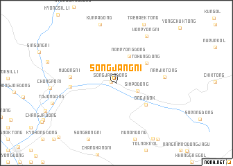
Sŏngjang-ni (Chagang, Korea, North)Sŏngjang-ni is a town in the Chagang region of Korea, North. An overview map of the region around Sŏngjang-ni is displayed below.
regional and 3d topo map of Sŏngjang-ni, Korea, North ::
Sŏngjang-ni airports ::
The nearest airport is FNJ - Pyongyang Intl, located 223.8 km south west of Sŏngjang-ni.
Nearby towns ::
Sŏngjang-dong (0.6km west) //
Simp'o-dong (2.9km south east) //
Namp'yŏng-dong (4.6km north) //
Tohŭng-dong (4.9km north east) //
Ongjidŏk (5.0km south east) //
Changgang-ŭp (5.6km west) //
Mudŏng-ni (5.7km west) //
Namjik-tong (5.9km east) //
Wŏnp'yŏng-ni (8.4km north east) //
[all distances 'as the bird flies' and approximate] 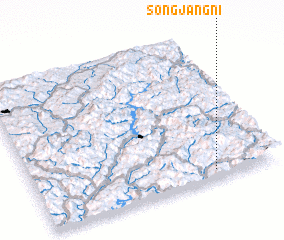 Places with similar names to Sŏngjang-ni, Korea, North ::
// Sangjangnae (KP)
// Sangjangnae (KP)
// Sangjang-ni (KP)
// Sangjung-ni (KP)
// Songjang-ni (KP)
// Songjŏng-ni (KP)
// Songjŏng-ni (KP)
// Songjŏng-ni (KP)
// Songjŏng-ni (KP)
// Songjŏng-ni (KP)
Disclaimer :: Information on this page comes without warranty of any kind |
||
|
Where is Sŏngjang-ni? Elevation and coordinates ::
Latitude (lat): 41°3'53"N Longitude (lon): 126°44'26"E
Elevation (approx.): 524m (map arrows pan, magnifying glasses zoom) |
||
|
Visiting Sŏngjang-ni? Hotel/Accommodation ::
Book a hotel in Sŏngjang-ni Travel Guide ::
rental cars ::
car rental offers GPS waypoint ::
download a GPX waypoint (PoI) of Sŏngjang-ni for your GPS receiver
|
||