|
search place name
|
||
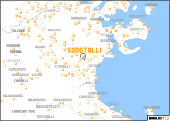
Songt'al-li (Kangwŏn, Korea, North)Songt'al-li is a town in the Kangwŏn region of Korea, North. An overview map of the region around Songt'al-li is displayed below.
regional and 3d topo map of Songt'al-li, Korea, North ::
Songt'al-li airports ::
The nearest airport is FNJ - Pyongyang Intl, located 144.7 km west of Songt'al-li.
Other airports nearby include SHO - Sokch'o Sokcho (167.3 km south east), GMP - Seoul Gimpo (197.7 km south), SSN - Seoul East Seoul Ab (205.2 km south), KAG - Kangnung Gangneung (219.9 km south east), Nearby towns ::
Ongnyu-dong (0.5km north east) //
Sangp'yŏng (0.6km south east) //
Yongt'al-li (0.8km north west) //
Yongyŏn (1.0km west) //
Okchŏng-ni (1.0km east) //
Ch'a-dong (1.9km south) //
Sŭngyang-ni (1.8km south west) //
Hwangsŏng-ni (1.7km north east) //
Sudal-li (2.2km south) //
Sŏkhyŏl-li (1.9km north west) //
Sang-dong (2.4km south) //
Yongp'yŏng-ni (2.0km south west) //
Yangji-ri (2.3km south west) //
Samsŏng-ni (2.3km north west) //
Sangjang-dong (2.2km north east) //
Yongjŏng-ni (2.6km north west) //
Tangmoro-ri (2.8km north) //
Saesulmak (2.9km south) //
Yat'ae-ri (2.6km south east) //
Chung-dong (2.8km south east) //
Chugyo-ri (2.4km north west) //
Munp'yŏng-dong (2.8km south east) //
Sahŭlch'ŏl-li (2.4km east) //
Yangji-dong (3.2km south) //
Hoeam-ni (2.8km north west) //
Kuhang-ni (3.0km north west) //
Chigyŏng-ni (3.5km south) //
Ha-dong (3.6km south east) //
Namch'ang-ni (3.5km south west) //
[all distances 'as the bird flies' and approximate]  Places with similar names to Songt'al-li, Korea, North ::
// Singut Alè (MM)
// Sangatile (CD)
// Sangatile (CD)
// Sunkatal (IN)
// Zaina Kadal (IN)
// Sancadilla (VE)
// Zancudal (VE)
// Sangdaeil-li (KP)
// Sangdal-li (KP)
// Sangdal-li (KP)
Disclaimer :: Information on this page comes without warranty of any kind |
||
|
Where is Songt'al-li? Elevation and coordinates ::
Latitude (lat): 39°17'8"N Longitude (lon): 127°20'39"E
Elevation (approx.): 17m (map arrows pan, magnifying glasses zoom) |
||
|
Visiting Songt'al-li? Hotel/Accommodation ::
Book a hotel in Songt'al-li Travel Guide ::
rental cars ::
car rental offers GPS waypoint ::
download a GPX waypoint (PoI) of Songt'al-li for your GPS receiver
|
||