|
search place name
|
||
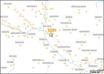
Sŏ-ri (Hamgyŏng, Korea, North)Sŏ-ri is a town in the Hamgyŏng region of Korea, North. An overview map of the region around Sŏ-ri is displayed below.
regional and 3d topo map of Sŏ-ri, Korea, North ::
Nearby towns ::
Nahadae-ri (1.1km north west) //
Pung-ni (1.4km east) //
Han-ch'on (2.0km north west) //
Sŏjangnae-ri (2.0km north west) //
Pukch'ŏng-ŭp (2.4km south east) //
Ch'ŏnghŭng-ni (3.1km south) //
Tangp'o-ri (3.0km south) //
Sin-ch'on (2.8km north west) //
Tap-tong (3.0km north west) //
Masal-li (3.0km south west) //
Chuksang-ni (3.3km north east) //
Ch'o-ri (4.2km south) //
Chak-tong (4.6km north) //
Yangji-ch'on (4.7km north west) //
Kumip'o (6.0km north) //
Susŏ-ri (5.7km north west) //
Sudong-ni (6.3km north) //
Changhang-ni (5.8km south east) //
Tangu-ri (6.5km south) //
Puksang-ni (5.7km north east) //
Chungp'yŏng-ni (5.3km east) //
Ogu (6.7km north) //
Huae-ch'on (5.7km north west) //
Chukchŏn-ni (7.1km north) //
Chung-ni (5.5km west) //
Chimal-li (7.4km south) //
Tŏksŏng-ŭp (7.3km north) //
Tŏgudae-ri (6.3km north west) //
Chang-ch'on (7.0km north west) //
[all distances 'as the bird flies' and approximate]  Places with similar names to Sŏ-ri, Korea, North ::
Disclaimer :: Information on this page comes without warranty of any kind |
||
|
Where is Sŏ-ri? Elevation and coordinates ::
Latitude (lat): 40°15'22"N Longitude (lon): 128°17'31"E
Elevation (approx.): 70m (map arrows pan, magnifying glasses zoom) |
||
|
Visiting Sŏ-ri? Hotel/Accommodation ::
Book a hotel in Sŏ-ri Travel Guide ::
rental cars ::
car rental offers GPS waypoint ::
download a GPX waypoint (PoI) of Sŏ-ri for your GPS receiver
|
||