|
search place name
|
||
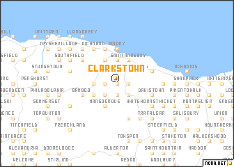
Clarks Town (Saint Ann, Jamaica)Clarks Town is a town in the Saint Ann region of Jamaica. An overview map of the region around Clarks Town is displayed below.
regional and 3d topo map of Clarks Town, Jamaica ::
Clarks Town airports ::
The nearest airport is OCJ - Ocho Rios Boscobel, located 26.2 km east of Clarks Town.
Other airports nearby include KTP - Kingston Tinson Pen (61.7 km south east), KIN - Kingston Norman Manley Intl (68.6 km south east), MBJ - Montego Bay Sangster Intl (74.5 km west), POT - Port Antonio Ken Jones (75.5 km east), Nearby towns ::
Friendship (0.0km north) //
Sea View (0.0km north) //
Arthurs Mount (1.8km west) //
Chesterfield (1.9km south) //
Higgin Town (1.9km south) //
Lime Hall (1.8km east) //
Sussex (1.9km north) //
Content (2.6km south west) //
Golden Grove (2.6km south west) //
Forest (2.6km south west) //
Pilot (2.6km south west) //
Winefield (2.6km south east) //
Breezy Park (2.6km south east) //
Golden (2.6km south east) //
Windsor Heights (2.6km north east) //
Johnston Village (3.5km west) //
Seville (3.7km north) //
Seville Heights (3.7km north) //
Mango Grove (4.1km south west) //
Lumsdale (4.1km south west) //
Lewis (4.1km north west) //
Tanglewood (4.1km north west) //
Thatch Walk (4.0km south west) //
Industry (4.0km south west) //
Wakefield (4.0km north west) //
Saint Annʼs Bay (4.1km north east) //
Priory (5.6km north) //
Banks (5.8km north) //
Bamboo (5.6km west) //
[all distances 'as the bird flies' and approximate] 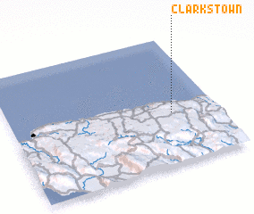 Places with similar names to Clarks Town, Jamaica ::
// Clarkston (US)
// Clarkston (US)
// Clarkston (US)
// Clarkstown (US)
// Clarkstown (US)
// Clarkston (US)
// Clarkston (US)
// Galera Costeña (MX)
// Clarks Town (JM)
// Clarks Town (JM)
Disclaimer :: Information on this page comes without warranty of any kind |
||
|
Where is Clarks Town? Elevation and coordinates ::
Latitude (lat): 18°24'0"N Longitude (lon): 77°13'0"W
Elevation (approx.): 406m (map arrows pan, magnifying glasses zoom) |
||
|
Visiting Clarks Town? Hotel/Accommodation ::
Book a hotel in Clarks Town Travel Guide ::
Buy a travel guide for Jamaica rental cars ::
car rental offers GPS waypoint ::
download a GPX waypoint (PoI) of Clarks Town for your GPS receiver
|
||