|
search place name
|
||
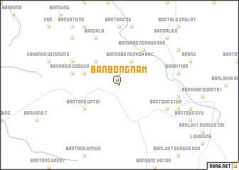
Ban Bông-Nam (Laos)Ban Bông-Nam is a town in Laos. An overview map of the region around Ban Bông-Nam is displayed below.
regional and 3d topo map of Ban Bông-Nam, Laos ::
Ban Bông-Nam airports ::
The nearest airport is PKZ - Pakse, located 131.3 km south west of Ban Bông-Nam.
Other airports nearby include DAD - Danang Intl (169.5 km east), ZVK - Savannakhet (207.8 km west), Nearby towns ::
Ban Sabong-Kôk-Hai (1.9km north) //
Ban Sabong-Phoham (2) (4.1km north east) //
Ban Lavi-Phokaming (5.1km north west) //
Ban Lavi-Phothong (5.7km west) //
Ban Tang-Un Tai (6.5km south west) //
Ban Sabong-Phoham (1) (6.6km north east) //
Ban Pasing-Souxou (7.4km west) //
Ban Toungyun (8.0km south east) //
Ban Pasing-Takia (8.0km north west) //
Ban Sala (8.2km north west) //
Ban Ralao (10.3km north east) //
Ban Chénnomuang (10.3km north west) //
[all distances 'as the bird flies' and approximate] 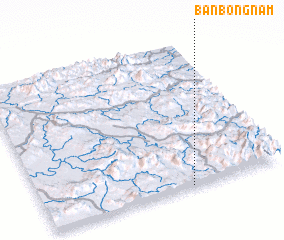 Places with similar names to Ban Bông-Nam, Laos ::
// Ban Bouang-Nom (LA)
Disclaimer :: Information on this page comes without warranty of any kind |
||
|
Where is Ban Bông-Nam? Elevation and coordinates ::
Latitude (lat): 16°0'0"N Longitude (lon): 106°37'0"E
Elevation (approx.): 569m (map arrows pan, magnifying glasses zoom) |
||
|
Visiting Ban Bông-Nam? Hotel/Accommodation ::
Book a hotel in Ban Bông-Nam Travel Guide ::
Buy a travel guide for Laos rental cars ::
car rental offers GPS waypoint ::
download a GPX waypoint (PoI) of Ban Bông-Nam for your GPS receiver
|
||