|
search place name
|
||
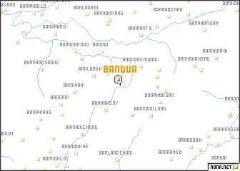
Ban Dua (Laos)Ban Dua is a town in Laos. An overview map of the region around Ban Dua is displayed below.
regional and 3d topo map of Ban Dua, Laos ::
Ban Dua airports ::
The nearest airport is LPQ - Luang Prabang Luang Phabang Intl, located 102.4 km east of Ban Dua.
Other airports nearby include THL - Tachilek Tachileik (139.4 km west), MOG - Mong Hsat (208.7 km west), KET - Kengtung (211.1 km north west), PRH - Phrae (243.2 km south west), Nearby towns ::
Ban Kang (2.5km north west) //
Ban Kalôm (3.4km north) //
Ban Langkay (4.1km west) //
Ban Môksoy (4.4km south west) //
Ban Kangmuang (4.3km north east) //
Ban Kongvan (4.9km south) //
Ban Tangya (5.5km east) //
Ban Mai (5.9km north west) //
Ban Longlou (5.7km east) //
Ban Phoutoum (6.2km north east) //
Ban Konglang (6.6km south east) //
Ban Phousan (6.5km south east) //
Ban Namphak (6.7km east) //
Ban Khak (6.8km west) //
Ban Kaphong (7.0km north west) //
Ban Namtè (8.5km north) //
Ban Khanong (8.4km north west) //
Ban Môkchong (9.4km south west) //
[all distances 'as the bird flies' and approximate] 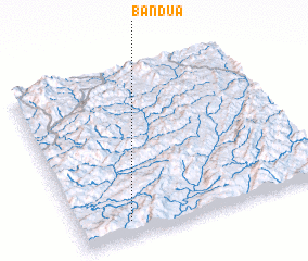 Places with similar names to Ban Dua, Laos ::
Disclaimer :: Information on this page comes without warranty of any kind |
||
|
Where is Ban Dua? Elevation and coordinates ::
Latitude (lat): 20°5'40"N Longitude (lon): 101°12'16"E
Elevation (approx.): 703m (map arrows pan, magnifying glasses zoom) |
||
|
Visiting Ban Dua? Hotel/Accommodation ::
Book a hotel in Ban Dua Travel Guide ::
Buy a travel guide for Laos rental cars ::
car rental offers GPS waypoint ::
download a GPX waypoint (PoI) of Ban Dua for your GPS receiver
|
||